Groundbreaking Discovery: Tsunamis Visualized for the First Time!
2025-07-24
Author: Ming
In an astonishing turn of events, a swarm of seismic detectors around the globe began to record mysterious tremors in September 2023. Every 90 seconds, the Earth seemed to shudder, leaving scientists baffled. After weeks of investigation, a second similar signal surfaced in October, prompting theoretical studies to propose that these tremors were linked to enormous tsunamis triggered by landslides in a narrow waterway off Greenland's coast.
Validation from Oxford's Engineers
Researchers from the University of Oxford have confirmed this unusual phenomenon. Using advanced satellite data from the Surface Water Ocean Topography (SWOT) mission, the team constructed groundbreaking images of the seiches that originated from these mega-tsunamis in Dickson Fjord, Greenland. While such colossal events are rare, further research indicates that climate change could increase their occurrence, highlighting the need for ongoing investments in advanced monitoring technologies.
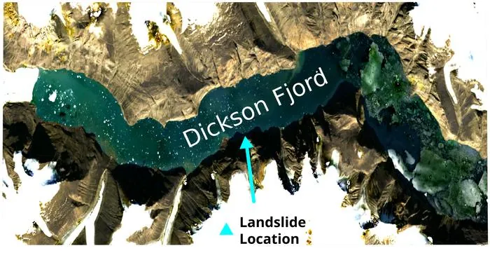
Unprecedented Insights into Dickson Fjord
Unlike conventional altimeters, SWOT captures two-dimensional sea surface height measurements with unrivaled precision—all the way down to the centimeter—even in challenging terrains like fjords and rivers. Team co-leader Thomas Monahan emphasized the importance of this data: "It provided us with an unprecedented view of Dickson Fjord during these seismic events in September and October 2023." With high-resolution images revealing how the water surface tilted, the researchers could effectively measure the 'slope' of these seiches.
A Titanic Force to Be Reckoned With
The maps indicated cross-channel slopes with height differences reaching up to two meters, showcasing water movement in both directions. Yet, proving that they had indeed observed seiches and not another oceanographic phenomenon proved to be challenging. Monahan described the process as akin to solving a mystery, as the team systematically eliminated alternate explanations. By linking their slope measurements with ground-based seismic data, they uncovered the seiche's size and characteristics.
The Earth Shook for Days!
Although no observers were present within Dickson Fjord during these incredible events, the team estimates that witnessing them would have been nothing short of terrifying. Analyses suggest that the first seiche was an astonishing 7.9 meters tall, while the October event reached about 3.9 meters. Monahan noted, "The force generated by such volumes of water sloshing across a 10-km section of fjord walls is monumental—equivalent to 14 Saturn V rockets launching simultaneously! It literally shook the Earth for days.".
Climate Change: A Contributing Factor?
The shape of the fjord played a crucial role in this seismic spectacle. Monahan explained, "A sharp bend near its outlet trapped the seiches, allowing them to reverberate for days." This constant barrage against the fjord walls pounded the Earth’s crust, creating long-period seismic waves detectable worldwide. Pertinently, Monahan suggested that climate change could be linked to these landslides. As glaciers retreat, they undergo 'de-buttressing,' which destabilizes the surrounding rocks, leading to catastrophic landslides. He warned, "The risk of tsunamigenic landslides will increase as global warming continues. We're likely facing more frequent and intense geological events in steep, icy regions."
The Road Ahead: Understanding Seiche Dissipation
The researchers are eager to further explore how these seiches dissipated over time. Monahan noted, "While we have simulated how the megatsunamis transitioned into seiches, their decay remains a poorly understood process. Future studies could leverage SWOT data to illuminate these mechanisms more clearly."


 Brasil (PT)
 Canada (EN)
 Chile (ES)
 Česko (CS)
 대한민국 (KO)
 España (ES)
 France (FR)
 Hong Kong (EN)
 Italia (IT)
 日本 (JA)
 Magyarország (HU)
 Norge (NO)
 Polska (PL)
 Schweiz (DE)
 Singapore (EN)
 Sverige (SV)
 Suomi (FI)
 Türkiye (TR)
 الإمارات العربية المتحدة (AR)