Unveiling IDEA: The Cutting-Edge AI Revolutionizing Geoscience Exploration
2025-08-11
Author: John Tan
A Game-Changer for Geoscience
A groundbreaking artificial intelligence tool, named the Intelligent Data Exploring Assistant (IDEA), has emerged from the research labs of the University of Hawai‘i at Mānoa. This pioneering software makes it a breeze for scientists to navigate the intricate world of geoscience data—from monitoring sea level fluctuations on Earth to scrutinizing atmospheric conditions on Mars.
Harnessing the Power of AI
At its core, IDEA integrates advanced large language models, akin to those found in ChatGPT, with complex scientific datasets and tailored instructions. Researchers can pose their questions in simple, everyday language, enabling IDEA to fetch data, conduct analyses, create visualizations, and even critique its own findings—transforming the landscape of research and education.
Lead author Matthew Widlansky, associate director at the UH Sea Level Center, described it best: "We've created a prototype that allows scientists to ask straightforward questions and receive not just actionable code but also clear explanations and publication-ready figures—all within minutes." Their research breakthrough was recently featured in the Journal of Geophysical Research: Machine Learning and Computation.
A Prototype with Sea-Level Savvy
Alongside co-author Nemanja Komar, Widlansky also developed the Station Explorer Assistant (SEA), a practical application of the broader IDEA framework. SEA simplifies the analysis of global sea level observations, empowering researchers and students to explore coastal changes without needing coding expertise.
"With SEA, users are freed from the complexity of writing code to analyze tide gauge data, track sea level rise, or understand flooding patterns," explained Widlansky.
Endless Possibilities and Cautionary Notes
One of the most exciting aspects of IDEA is its adaptability. It can seamlessly transition from handling sea level records to analyzing Martian dust storms with just a shift in data sources and instructions. However, researchers warn that while IDEA is powerful, it isn't infallible. Widlansky highlighted, "AI-generated analyses can sometimes miscalculate trends, so human oversight is crucial—we're here to support scientists, not to replace them."
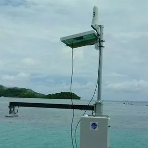
Innovative Tide Gauge Analysis
To build the SEA tool, the team linked a large language model service from OpenAI to access the UH Sea Level Center’s comprehensive data archives. They equipped the model with specific instructions—a virtual guide to untangling tide gauge data. This innovative structure allows SEA to interpret coastal water level data and assess trends effortlessly, making it accessible for anyone interested.
Versatile Applications Ahead
Despite its current focus on sea level data, the IDEA framework is versatile and ready for a multitude of geoscience topics. The researchers showcased its flexibility by adapting the framework to atmospheric data on Mars, demonstrating how user-friendly it is to pivot between diverse datasets.
While still a prototype, SEA is available online for both scientists and students to test. Developers can explore the IDEA framework on GitHub, experimenting with their own data or other large language model services. The team encourages feedback and collaboration to further improve and expand IDEA's capabilities.
The Future of Scientific Exploration
Looking ahead, the researchers aim to enhance IDEA's functionality and increase its user engagement. Planned updates include automated quality checks to minimize plotting errors, support for new data sources, and even features that allow users to create custom assistants for various geoscience challenges. With tools like SEA and IDEA constantly evolving, Widlansky and Komar envision a future where scientific exploration is vastly more accessible, benefiting students, educators, and researchers not just in Hawai‘i, but across the globe.

 Brasil (PT)
 Canada (EN)
 Chile (ES)
 Česko (CS)
 대한민국 (KO)
 España (ES)
 France (FR)
 Hong Kong (EN)
 Italia (IT)
 日本 (JA)
 Magyarország (HU)
 Norge (NO)
 Polska (PL)
 Schweiz (DE)
 Singapore (EN)
 Sverige (SV)
 Suomi (FI)
 Türkiye (TR)
 الإمارات العربية المتحدة (AR)