Unveiling Antarctica: The Most Comprehensive Map of Submarine Canyons Yet!
2025-08-11
Author: Nur
Dive into Antarctica's Hidden Treasures
Submarine canyons, those majestic and mysterious formations lurking below the ocean's surface, have long been a source of intrigue for scientists. However, many of their secrets remain buried beneath remote polar waters—until now!
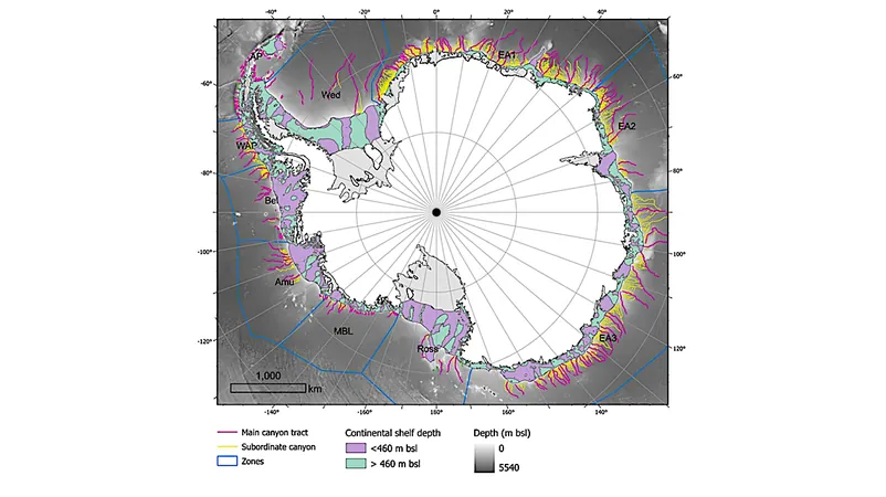
Recently published in the prestigious journal Marine Geology, groundbreaking research has unveiled the most extensive catalog of Antarctic submarine canyons to date. This comprehensive study identifies an astonishing **332 canyon networks**, some plunging to depths exceeding **4,000 meters**.
Meet the Pioneers Behind the Discovery
The monumental work was spearheaded by researchers **David Amblàs** from the University of Barcelona and **Riccardo Arosio** from University College Cork. Their meticulous research highlights that these canyons may significantly influence not only ocean circulation and ice-shelf dynamics but also global climate change, particularly in sensitive regions such as the **Amundsen Sea**.
East vs. West: The Canyon Showdown
The study draws fascinating distinctions between the submarine canyons of East and West Antarctica. While scientists have cataloged approximately **10,000 submarine canyons** globally, only **27%** of the ocean floor has been mapped in detail—suggesting the actual number could be much greater. Amblàs explains, "Antarctic canyons, while similar to those found elsewhere, tend to be larger and deeper due to the relentless force of polar ice and massive sediment transported by glaciers."
Unique features emerge as East Antarctic canyons display a more complex and branched structure, often forming extensive U-shaped valley systems—as opposed to the shorter, steeper, V-shaped canyons of the West.
Mapping with Precision: A New Era for Oceanography
Utilizing the **International Bathymetric Chart of the Southern Ocean (IBCSO v2)**, this study benefits from a high-resolution mapping technique that drastically enhances canyon identification. With a resolution of **500 meters per pixel** compared to previous maps at **1-2 kilometers**, researchers can now employ semi-automated techniques for identifying and analyzing canyons with unprecedented accuracy.
Climate Connections: The Role of Submarine Canyons
These incredible canyons aren't just geological wonders—they are pivotal in facilitating the exchange of water between the continental shelf and the deep ocean. This process forms the crucial **Antarctic Bottom Water**, a key player in global ocean circulation and climate regulation. As warmer waters flow through these canyons, they contribute to the melting of crucial floating ice shelves, which, when collapsed, accelerate ice flow into the sea and directly impact rising global sea levels.
Amblàs and Arosio's findings indicate that existing ocean circulation models likely fail to accurately replicate the complex interactions within these canyons, hindering our understanding of broader climate dynamics. Therefore, continued high-resolution mapping is imperative to uncover more canyons and refine climate models.
The Road Ahead: Mapping the Unseen
The team urges the scientific community to ramp up efforts in **data collection** and **observation** in these unmapped areas. They emphasize that every new canyon discovered holds the potential to reshape our understanding of oceanography and climate science.
In a world facing the looming threats of climate change, the detailed study of submarine canyons offers not just insight into our planet's past, but an essential tool for navigating its future.


 Brasil (PT)
 Canada (EN)
 Chile (ES)
 Česko (CS)
 대한민국 (KO)
 España (ES)
 France (FR)
 Hong Kong (EN)
 Italia (IT)
 日本 (JA)
 Magyarország (HU)
 Norge (NO)
 Polska (PL)
 Schweiz (DE)
 Singapore (EN)
 Sverige (SV)
 Suomi (FI)
 Türkiye (TR)
 الإمارات العربية المتحدة (AR)