Sentinel-2C Takes Breathtaking Lunar Snapshot: A New Era for Earth Observation!
2024-09-26
Author: Yu
Introduction
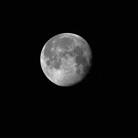
On September 20, 2024, the Copernicus Sentinel-2C satellite made headlines by capturing its first breathtaking image of the Moon through a pioneering sideways roll maneuver. Although initially designed primarily for Earth observation, this lunar image serves as a key component for calibration and provides a unique opportunity for cross-mission comparisons between various satellite systems.
Impressive Lunar Imagery
With an astonishing resolution of approximately 5 kilometers, the image showcases prominent lunar features such as the majestic Copernicus Crater, the distinctive Tycho Crater, and the vast lunar seas, including the Sea of Tranquility, the Sea of Moisture, and the Sea of Clouds. These details highlight the remarkable capabilities of Sentinel-2C's multispectral imager, which typically operates from an altitude of 786 kilometers to gather high-resolution data about Earth’s landscapes and coastal ecosystems.
Moon Calibration Process
This lunar observation is part of a routine process referred to as 'Moon calibration'. Roughly once a month, Sentinel-2C performs a sideways roll to capture snapshots of our Moon instead of focusing solely on Earth. The Moon's consistent and stable light intensity plays a crucial role in this process, allowing scientists to detect and correct even the slightest fluctuations in the satellite's instruments. Such corrections are vital as they can stem from factors like the aging of optical coatings and drifts in the detectors.
Importance of Radiometric Accuracy
Ensuring 'radiometric accuracy' is essential for the various applications relying on the satellite's data, and this meticulous calibration process contributes to that goal. Initially, the raw data presented an elongated, eclipse-shaped appearance of the Moon due to the relative motion between Sentinel-2C and its celestial neighbor. However, post-correction, the stunning imagery was successfully refined.
Launch and Future Missions
Launched on September 5, 2024, Sentinel-2C becomes part of a constellation of twin satellites working together to provide invaluable high-resolution imagery under the Copernicus program. This unprecedented initiative not only enhances our understanding of Earth but also contributes significantly to ongoing research in climate change, land use, and disaster management.
Conclusion
Stay tuned as Sentinel-2C prepares for its future missions, unlocking new insights into our planet and beyond!


 Brasil (PT)
 Canada (EN)
 Chile (ES)
 España (ES)
 France (FR)
 Hong Kong (EN)
 Italia (IT)
 日本 (JA)
 Magyarország (HU)
 Norge (NO)
 Polska (PL)
 Schweiz (DE)
 Singapore (EN)
 Sverige (SV)
 Suomi (FI)
 Türkiye (TR)