Revolutionizing Weather Forecasting: AI Uncovers Hidden Secrets of Our Atmosphere
2025-09-20
Author: Wei
Predicting extreme weather events has long been one of the toughest challenges in meteorology, primarily due to the need for precise humidity data. A groundbreaking study has just been released, detailing the first high-resolution tropospheric imaging using Global Navigation Satellite System (GNSS) technology, supercharged by Artificial Intelligence (AI).
Researchers utilized a cutting-edge Super-Resolution Generative Adversarial Network (SRGAN) to transform coarse atmospheric data into incredibly detailed 3D humidity maps. This innovation has led to a significant reduction in errors—over 50% in some instances—offering a promising leap forward in the accuracy of weather forecasts.
This new approach not only enhances precision but also provides insight into the AI's decision-making process, adding much-needed transparency to weather predictions. By harmonizing satellite signals with advanced AI techniques, this research could reshape how we understand local weather phenomena, significantly impacting human life.
For more than a century, our weather forecasting techniques have evolved, yet they still struggle with capturing small-scale weather events such as intense downpours and storm fronts. Traditional models often produce smoothed and imprecise atmospheric images, leaving vital details obscured.
Recognizing this crucial gap, a dedicated team from the Wrocław University of Environmental and Life Sciences has tackled the challenge of refining GNSS data while maintaining accuracy. Their research, recently published in Satellite Navigation, marks a milestone with the introduction of a deep learning framework capable of generating detailed GNSS tomography.
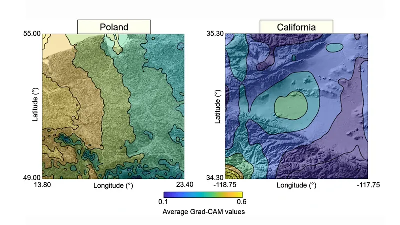
By training the SRGAN with outputs from weather models, the team achieved exceptional clarity in atmospheric representations. Tested in both Poland and California, this revolutionary system was able to refine humidity readings, while also revealing its logical processes through explainable AI techniques.
At the heart of this innovation lies a synthesis of GNSS tomography and the Weather Research and Forecasting (WRF) model, facilitated by the SRGAN's ability to act as a bridge between low and high-resolution data. In real-world tests, the efficacy of this method was staggering; error rates dropped by 62% in Poland and 52% in California under challenging weather conditions.
In comparison to traditional interpolation methods, the SRGAN provided sharper atmospheric details that aligned closely with verified weather data. The use of explainable AI tools, such as Grad-CAM and SHAP, illuminated the areas of focus for the model, pinpointing storm-sensitive zones in both regions.
This study not only showcases the potential for improved accuracy but also underscores the importance of interpretability in AI-based weather systems. As lead author Saeid Haji-Aghajany noted, "High-resolution atmospheric data is the missing link in forecasting disruptive weather. Our method doesn't merely enhance GNSS tomography; it illuminates how the AI makes its predictions, fostering trust in the technology as it integrates into forecasting.
The implications of this research extend far beyond academic interest. With more precise GNSS tomography, meteorologists can improve storm prediction and early warning systems, enabling communities at risk of natural disasters like flash floods or hurricanes to receive faster and more reliable alerts.
Moreover, the framework’s explainability facilitates validation of the system's decisions, enhancing confidence in its adoption. As we face the challenges of climate change, integrating this method into global weather networks could significantly bolster our resilience against increasingly unpredictable weather.
 Brasil (PT)
 Canada (EN)
 Chile (ES)
 Česko (CS)
 대한민국 (KO)
 España (ES)
 France (FR)
 Hong Kong (EN)
 Italia (IT)
 日本 (JA)
 Magyarország (HU)
 Norge (NO)
 Polska (PL)
 Schweiz (DE)
 Singapore (EN)
 Sverige (SV)
 Suomi (FI)
 Türkiye (TR)
 الإمارات العربية المتحدة (AR)