Revolutionizing Coastal Monitoring: How Satellite Technology Is Transforming Data Collection
2025-03-18
Author: Yu
Introduction
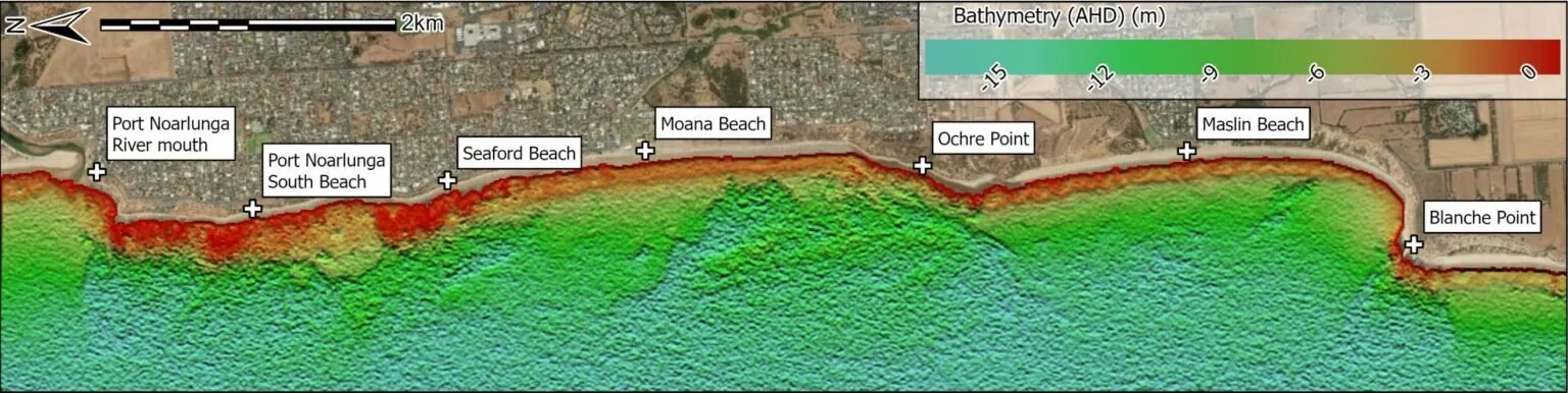
In an exciting development that could reshape coastal management practices, experts from Flinders University have unlocked a groundbreaking approach to bathymetry— the science of measuring underwater depth—using advanced satellite technology. This innovative technique is gaining traction in monitoring environmental changes along the vast coastline of South Australia.
Research Overview
The research, titled "Optimising Satellite-Derived Bathymetry Using Optical Imagery over the Adelaide Metropolitan Coast," is a recent entry in the journal Remote Sensing. It points to a shift from traditional methods like topographic profiling and boat-based sonar, which, though precise, are often hindered by prohibitive costs and lengthy survey times.
Professor Hesp's Insights
Professor Patrick Hesp, head of Environmental Science at Flinders, notes, "Traditional methods are currently the gold standard, but they come with significant limitations. Our new approach using Satellite-Derived Bathymetry (SDB) is not only cost-effective but vastly more efficient, especially for studying dynamic coastal environments."
Advantages of SDB
SDB leverages optical satellite imagery, making it an invaluable resource for understanding sand movement and monitoring the health of vital ecosystems such as seagrasses. The research highlights how this technique excels in low-energy coastal settings like those near Adelaide, utilizing an optimal combination of satellite imagery, spectral bands, and analytical techniques to yield unprecedented accuracy in seabed mapping.
Student Contribution
Joram Downes, a student who just completed his First-Class Honors thesis at Flinders, emphasizes the breakthrough potential of this technology. "Our study shows that satellite-derived bathymetry can significantly enhance our understanding of seabed changes. This is crucial for effective coastal management strategies," he explains.
Expert Validation
Associate Professor David Bruce, an authority in remote sensing at Flinders, further accentuates the impact of this study. "This advancement will complement existing data collection methods and fill significant gaps in knowledge, particularly in discovering areas of the underwater landscape that are still unknown."
Validation Process
The team validated their findings through extensive calibration, drawing from over a million ground observations, and identified a highly effective method utilizing low-cost satellite data from the PlanetScope SuperDove constellation.
Technological Integration
In a further nod to technological integration, the research incorporated cutting-edge drone-based LiDAR (Light Detection and Ranging) systems, aimed at capturing high-resolution data in shallow waters. Associate Professor Graziela Miot da Silva expressed her enthusiasm about the collaborative potential of these technologies, stating, "Witnessing the seamless operation of LiDAR alongside satellite imagery was exhilarating. The data quality obtained in shallow areas closely matched that from traditional sonar methods, opening up new avenues for precision in coastal studies."
Conclusion
With the potential to revolutionize how researchers monitor and manage coastal areas, this pioneering work at Flinders University sets a new standard in coastal data collection. As we face increasing environmental challenges, advancements in satellite technology like these could be vital in preserving our coastlines for future generations.


 Brasil (PT)
 Canada (EN)
 Chile (ES)
 Česko (CS)
 대한민국 (KO)
 España (ES)
 France (FR)
 Hong Kong (EN)
 Italia (IT)
 日本 (JA)
 Magyarország (HU)
 Norge (NO)
 Polska (PL)
 Schweiz (DE)
 Singapore (EN)
 Sverige (SV)
 Suomi (FI)
 Türkiye (TR)
 الإمارات العربية المتحدة (AR)