Breakthrough Discovery: Ships Detect Tsunamis from Landslides!
2025-05-19
Author: Rajesh
Dangers of Landslide-Generated Tsunamis
Landslide-generated tsunamis are a hidden threat to coastal communities, particularly in narrow fjords where towering cliffs can amplify wave intensity. While traditional tsunami warnings rely on earthquake-based systems, these methods often fail to account for the localized movements caused by catastrophic landslides.
A Revolutionary Method of Detection
In an exciting new development, scientists have successfully used data from a ship's satellite system to detect tsunami waves triggered by a landslide. This groundbreaking study, led by researchers from CIRES and CU Boulder and recently published in Geophysical Research Letters, demonstrates a promising new approach to enhance tsunami detection and provide crucial warnings to at-risk coastal populations.
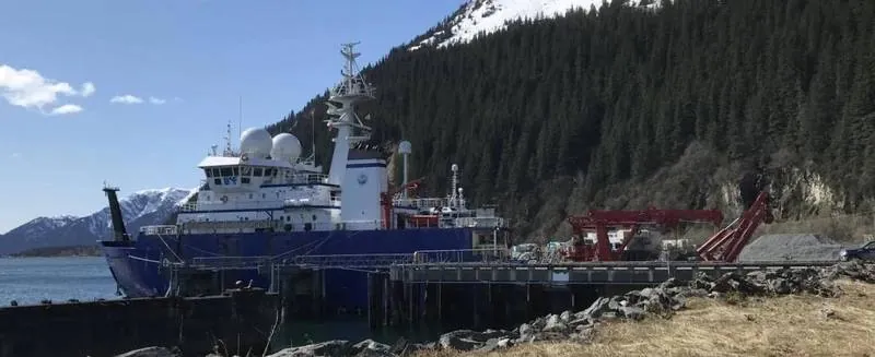
The First-Ever Detection from a Ship!
Landslides can unleash powerful tsunamis, and this study is a game changer. Anne Sheehan, a CIRES Fellow and professor at CU Boulder, emphasized the significance: 'Our team managed to capture the phenomenon when we had equipment in the right place.' The remarkable event occurred on May 8, 2022, near Seward, Alaska, where a landslide released debris into Resurrection Bay, generating a series of energy-rich tsunami waves.
Cutting-Edge Technology at Work
The R/V Sikuliaq, a National Science Foundation research vessel operated by the University of Alaska Fairbanks, was ideally positioned just 650 meters away when the landslide struck. Equipped with an external Global Navigation Satellite System (GNSS) receiver, previously installed by the ship’s science operations manager, Ethan Roth, the ship became a key player in this research.
Tracking the Tsunami in Real Time
Graduate student Adam Manaster, who spearheaded the project, collaborated with scientists from the US Geological Survey (USGS) and the University of Alaska Fairbanks. The team utilized data from the ship's GNSS system and sophisticated open-source software to trace the ship’s vertical movements with remarkable precision, creating a timeline of the incident.
Confirming the Discovery
By comparing the ship's data to a specialized tsunami model, researchers confirmed that the ship’s movements were in sync with the landslide event, marking the first recorded instance of a landslide-generated tsunami detected using a satellite navigation system aboard a ship.
A Life-Saving Leap Forward
Manaster stated, 'Our research shows that ships can play a vital role in tracking the timing and extent of these tsunami-generating landslides. If we can process the data quickly enough, we could send timely warnings to those in harm’s way.' This research builds on earlier CIRES studies, showcasing how GPS data from vessels can significantly bolster tsunami early warning systems.
Collaborating for a Safer Future
Sheehan noted that many vessels now have real-time GPS capabilities. To implement this revolutionary method on a broader scale, collaboration with the shipping industry is essential to ensure that on-board data is accessible to scientists, ultimately enhancing safety for coastal communities at risk of these hidden but deadly threats.


 Brasil (PT)
 Canada (EN)
 Chile (ES)
 Česko (CS)
 대한민국 (KO)
 España (ES)
 France (FR)
 Hong Kong (EN)
 Italia (IT)
 日本 (JA)
 Magyarország (HU)
 Norge (NO)
 Polska (PL)
 Schweiz (DE)
 Singapore (EN)
 Sverige (SV)
 Suomi (FI)
 Türkiye (TR)
 الإمارات العربية المتحدة (AR)