Tropical Storm John Gears Up for Another Assault on Mexico: What You Need to Know
2024-09-26
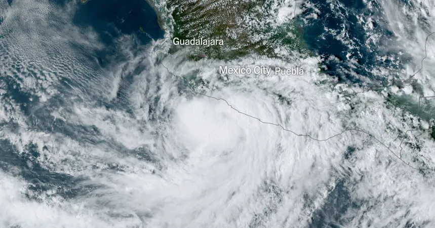
Tropical Storm John Intensifies
In a dramatic turn of events, Tropical Storm John is intensifying over the Pacific Ocean and is on track to become a hurricane once again, threatening to make landfall in Mexico, where it previously wreaked havoc earlier this week, resulting in the tragic deaths of at least two individuals.
Hurricane Warnings and Predictions
The National Hurricane Center predicts that John will regain hurricane strength, potentially reaching Category 2 status by Thursday night, with landfall expected near the southwestern city of Lázaro Cárdenas. This will mark the storm's second strike on Mexico in just a matter of days.
Currently, a hurricane warning is active from Tecpan de Galeana to Punta San Telmo, indicating that hurricane conditions could be felt within the next 36 hours. Additionally, tropical storm warnings are in effect from Punta Maldonado to Tecpan de Galeana and from Punta San Telmo to Manzanillo, as forecasters brace for substantial impacts.
Impact of Earlier Landfall
Earlier this week, on Monday, John escalated from a tropical storm to a formidable Category 3 hurricane, delivering maximum sustained winds of around 120 miles per hour as it made its initial landfall. Following its decrease in intensity while over land on Tuesday, residents have been warned to remain vigilant as flash flooding poses a continued threat across southern and southwestern Mexico.
Rainfall and Flooding Concerns
By Tuesday morning, communities in Guerrero and Oaxaca, two of Mexico’s most impoverished regions, had already experienced over 10 inches of rainfall. The situation worsened, as forecasts predict an additional 10 to 20 inches of rain will fall in affected states including Guerrero, Oaxaca, coastal Chiapas, and coastal Michoacán through Friday.
Warnings from Officials
The heavy rainfall spells disaster, with meteorologists warning of 'catastrophic, life-threatening flash flooding and mudslides' along Mexico's coast. In light of the impending threat, Mexico's President Andrés Manuel López Obrador has urged those in high-risk areas to 'seek higher ground,' emphasizing the importance of prioritizing personal safety over material possessions.
Local Reports
Evelyn Salgado, the governor of Guerrero, reported that the most devastating effects of the storm were witnessed in her state, particularly in the municipality of Tlacoachistlahuaca, where the landslide resulted in the loss of two lives. The storm also left approximately 60,000 residents without power, causing significant damage by uprooting trees and blocking key roadway access.
Wider Context and Concerns
In a broader context, a recent study indicates that rapid intensification, as seen with John, has become twice as likely, especially for Atlantic hurricanes, a change largely attributed to human-induced climate change from fossil fuel consumption.
Common Origins of Storms
Interestingly, John is the 10th named storm of the Eastern Pacific season for 2024, coinciding with the dangerous Atlantic Hurricane Helene, which is expected to make landfall in Florida. Both storms share a common origin, having formed from the same atmospheric system known as the Central American gyre—this widespread area of storm activity across Central America has spawned both Helene and John, leading to increased concerns for further destructive weather patterns.
Conclusion and Safety Measures
Stay tuned for further developments as the situation unfolds and ensure you follow all safety protocols if you are in the affected areas.


 Brasil (PT)
 Canada (EN)
 Chile (ES)
 España (ES)
 France (FR)
 Hong Kong (EN)
 Italia (IT)
 日本 (JA)
 Magyarország (HU)
 Norge (NO)
 Polska (PL)
 Schweiz (DE)
 Singapore (EN)
 Sverige (SV)
 Suomi (FI)
 Türkiye (TR)