Florida Faces Urgent Preparations as Hurricane Helene Intensifies
2024-09-25
Hurricane Helene's Intensification
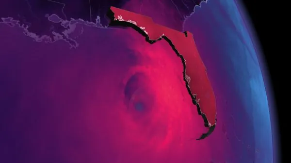
As Hurricane Helene intensifies over the warm waters of the Gulf of Mexico, Florida is bracing for a powerful storm set to make landfall on Thursday. The storm's impending arrival poses serious threats, including storm surge, excessive rainfall, flooding, damaging winds, and the risk of tornadoes for the Florida Panhandle.
Forecast and Path
Currently, Helene is gathering strength, and the U.S. National Hurricane Center (NHC) forecasts that it will reach hurricane status by Wednesday. The storm is likely to rapidly intensify as it moves across the eastern Gulf, potentially becoming a major hurricane by Thursday. The NHC warns that if Helene follows its projected track, it will pass near northeastern Yucatan Peninsula and make critical landfall along the Big Bend coast of Florida.
Emergency Preparations
Emergency preparations are critical for coastal residents. Hurricane and tropical storm warnings are actively issued for parts of Florida and Mexico, with Tampa Bay under a storm surge warning. Evacuation orders should be heeded promptly to minimize the impact of the storm.
Potential for Rapid Intensification
Helene is projected to undergo rapid intensification within just 48 hours, thanks to extremely warm Gulf waters and minimal land interference. This allows the storm to grow its eye and strength, leading to concerns about widespread power outages and costly damage. The storm's path currently suggests landfall anywhere from Tampa to Tallahassee, but areas closer to Tampa will face higher risks.
Governor's Preparedness Message
Notably, Florida Governor Ron DeSantis emphasized the state’s readiness, stating that nearly 18,000 linemen and additional emergency crews are stationed to respond immediately. "Get preparations in place now for the storm and heed evacuation directives, if issued," he urged via social media.
Rainfall and Flooding Concerns
Rainfall accumulations are a significant concern as well, with totals of 100 to 200 mm expected across western Cuba and the Cayman Islands, and similar amounts in southeastern U.S. regions. This heavy rain can lead to flash flooding and significant river flooding, especially in areas prone to landslides in the southern Appalachians.
Catastrophic Flooding Risks
The combination of rising tides and storm surge could lead to catastrophic flooding in coastal regions. Tampa Bay could see surges between 1.5 to 2.5 meters, while areas along Florida's Ochlockonee River might experience surges reaching as high as 4.5 meters. If the surge measures as predicted, it could lead to devastating damage in these areas.
Size and Comparison to Other Hurricanes
What’s particularly alarming is the size of Hurricane Helene, which has a diameter extending over 800 kilometers—substantially larger than many recent storms. While Helene is projected to be 60 percent larger than Hurricane Idalia, which caused $3.6 billion in damage, it's still half the width of Hurricane Sandy.
Stay Vigilant
As we move deeper into what has been an unusually quiet hurricane season, experts urge residents along the coast to remain vigilant. Dangerous storms could emerge in the coming days, and having an emergency preparedness kit ready is crucial, regardless of the current forecast.
Conclusion
With close monitoring of Hurricane Helene and its potential impacts, the people of Florida are reminded that their safety should always be a priority. Stay tuned for further updates as the situation develops.


 Brasil (PT)
 Canada (EN)
 Chile (ES)
 España (ES)
 France (FR)
 Hong Kong (EN)
 Italia (IT)
 日本 (JA)
 Magyarország (HU)
 Norge (NO)
 Polska (PL)
 Schweiz (DE)
 Singapore (EN)
 Sverige (SV)
 Suomi (FI)
 Türkiye (TR)