Unveiling the Secrets of Water Tracks: Nature's Thawing Highways
2025-06-25
Author: Wei
Water Tracks: The Lifeblood of Thawing Arctic Landscapes
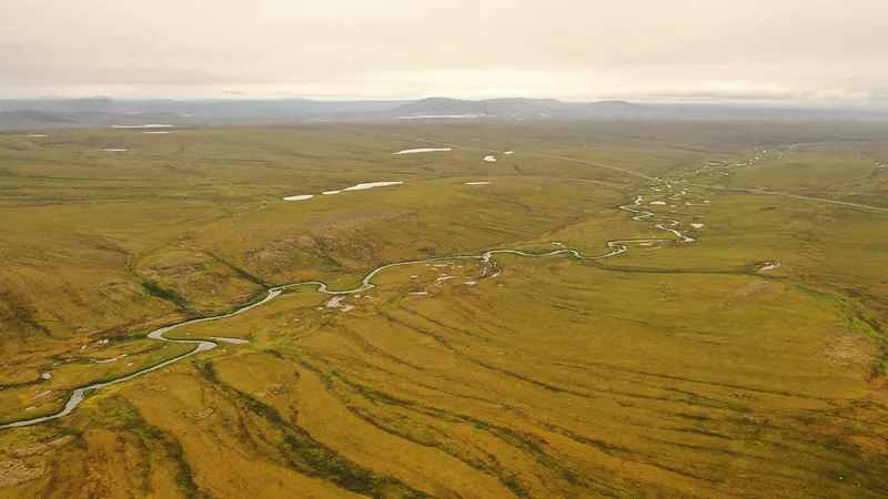
In the heart of the Arctic, water flows through a unique system known as water tracks—natural conduits that redirect melted water during the summer thaw. When the permafrost melts, these stream-like features become vital arteries for transporting not just water but essential nutrients across frigid landscapes. Yet, despite their significance, the formation and future of water tracks remain largely mysterious.
What Are Water Tracks?
Water tracks are intriguing features that emerge in polar regions where ground icing persists throughout winter. As snow and ice melt during warmer months, the water cannot infiltrate the frozen ground and instead flows over the surface or just beneath the top layer, often saturating moss and soil. Unlike traditional streams, water tracks lack distinct channels and can form even on gentle slopes, making them prevalent in areas with permafrost, such as Alaska, northern Canada, and parts of Antarctica.
The Role of Water Tracks in Ecosystems
These natural channels play a crucial role in the nutrient cycling of polar ecosystems. By concentrating water from rainfall and meltwater, they become hotspots of vegetation and biodiversity. The lush growth found along these tracks often contrasts starkly with the surrounding barren lands, acting as a source of carbon dioxide and methane emissions—an important factor in our understanding of climate change.
How Do Scientists Study Water Tracks?
Tracking these features has evolved with technology. Initially observed from the skies, researchers now utilize advanced remote sensing tools like satellite imagery and drones. High-resolution images, especially those capturing infrared data, highlight these lush areas, while LiDAR technology aids in monitoring subtle topographical changes. Older satellite models may overlook these features, but modern advancements allow for far clearer detection.
Theories of Water Track Formation
Researchers have proposed two primary theories regarding the origin of water tracks. One suggests they are formed through thawing ground ice, creating linear pathways for water to follow. As ice melts, the process becomes self-sustaining, generating more thawing. The second theory posits that depressions in the permafrost, caused by elements like snowdrifts or vegetation, collect water, enhancing erosion and further developing the water track.
Impact of Climate Change on Water Tracks
Climate change looms large over the future of water tracks. As temperatures rise, earlier snowmelt and deeper soil thawing could dramatically alter water flow patterns, leading to erosion and transforming previously stable landscapes. Concerns are growing that water tracks might consolidate into fewer but deeper channels, potentially releasing stored sediments and carbon into the environment.
Lessons for Mars: Understanding Water Beyond Earth
Interestingly, researchers are looking to Earth’s water tracks to draw parallels with Martian features like recurring slope lineae. Both exhibit seasonal patterns in arid environments, suggesting that Earth's frozen landscapes could provide insights into how water might behave—or once behaved—on Mars, despite differing geological processes.
The Future of Water Tracks: Unanswered Questions
Despite advancing our understanding, much remains unknown. Current studies only scratch the surface, and there's a pressing need for more comprehensive data and modeling to predict how these vital features will respond to environmental changes. Questions about historical patterns and evolutionary trends of water tracks still await exploration, underscoring the necessity of ongoing research to unlock the secrets of these impressive natural phenomena.

 Brasil (PT)
 Canada (EN)
 Chile (ES)
 Česko (CS)
 대한민국 (KO)
 España (ES)
 France (FR)
 Hong Kong (EN)
 Italia (IT)
 日本 (JA)
 Magyarország (HU)
 Norge (NO)
 Polska (PL)
 Schweiz (DE)
 Singapore (EN)
 Sverige (SV)
 Suomi (FI)
 Türkiye (TR)
 الإمارات العربية المتحدة (AR)