Unveiling the Secrets of 'Mega-Tsunamis' that Rocked the World for Nine Days
2025-06-03
Author: Jia
A Seismic Event Like No Other
In a stunning revelation, scientists have finally unraveled the mystery behind a seismic phenomenon that shook the globe for an astonishing nine days in September 2023. This unprecedented event was triggered by two colossal 'mega-tsunamis' that surged through an East Greenland fjord, leaving experts in awe.
Colossal Waves That Defy Imagination
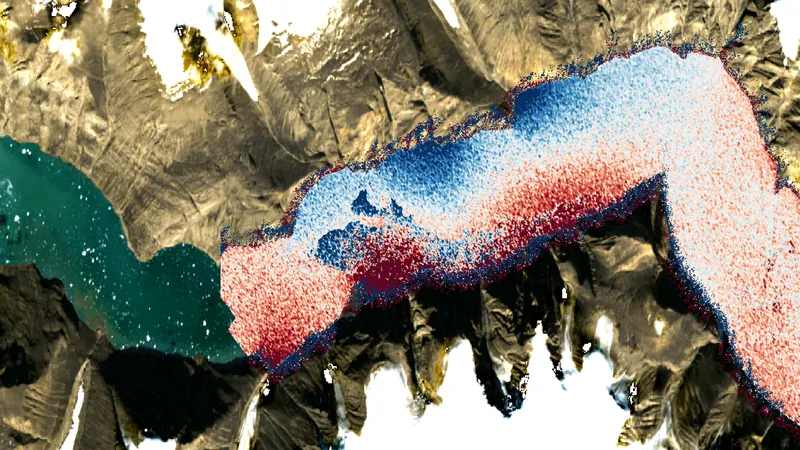
Among these gigantic waves was one that soared to a staggering height of 650 feet (about 200 meters)—around half the height of the iconic Empire State Building! These monstrous waves wreaked havoc in East Greenland's Dickson Fjord, repeatedly crashing and sloshing for nearly a week and sending seismic tremors rippling through the Earth's crust.
From Mystery to Revelation
Initially, the cause of this seismic signal perplexed researchers. However, through meticulous ground observations and satellite imagery, they traced it back to catastrophic landslides within the fjord, triggered by the climate-change-induced melting of a nearby glacier. Despite this, direct proof of the waves—known scientifically as seiches—had yet to be confirmed.
Satellite Technology Unleashed
In a groundbreaking advancement, a new satellite capable of monitoring surface water finally validated the theory. Published in the journal Nature Communications, the findings highlight how advanced satellite Earth observation technologies can shed light on the changing dynamics of our planet.
Harnessing the Power of Satellite Observation
Thomas Monahan, the study's lead author and a graduate student from the University of Oxford, emphasized the significance of these findings. "Climate change is fostering new and unseen extremes, particularly in remote regions like the Arctic. This new approach exemplifies how we can utilize satellite data to explore these phenomena," he stated.
A New Era of Understanding Tsunami Dynamics
Typically, scientists rely on a radar technique known as satellite altimetry to measure wave heights. However, they often face limitations in coverage and resolution when monitoring confined areas like fjords. That’s where the innovative Surface Water and Ocean Topography (SWOT) satellite, launched in December 2022, comes into play.
Equipped with the cutting-edge Ka-band Radar Interferometer, SWOT can map an incredible 90% of ocean surface water, achieving remarkable accuracy. When deployed above the fjord during the mega-tsunamis, this satellite data illuminated the presence of two opposing cross-channel slopes, confirming the seiche phenomenon.
The Future of Oceanic Research
Thomas Adcock, a co-author of the study, pointed out the potential impact of this research. "Next-generation satellite data unlocks insights into oceanic extremes like tsunamis and storm surges that were previously enigmatic," he explained. He also acknowledged the need to innovate, combining machine learning with ocean physics to fully harness these groundbreaking findings.
Conclusion: A Glimpse Into Our Planet’s Future
As scientists continue to harness advanced satellite technologies, the mysteries of our planet’s extreme phenomena may soon be fully unveiled. The revelations from these mega-tsunamis not only deepen our understanding of climate change's effects but also prepare us for the unexpected challenges that lie ahead.


 Brasil (PT)
 Canada (EN)
 Chile (ES)
 Česko (CS)
 대한민국 (KO)
 España (ES)
 France (FR)
 Hong Kong (EN)
 Italia (IT)
 日本 (JA)
 Magyarország (HU)
 Norge (NO)
 Polska (PL)
 Schweiz (DE)
 Singapore (EN)
 Sverige (SV)
 Suomi (FI)
 Türkiye (TR)
 الإمارات العربية المتحدة (AR)