Unveiling Nature's Secrets: How Satellite Technology Separates Snow from Clouds
2024-11-17
Author: Jia
Introduction
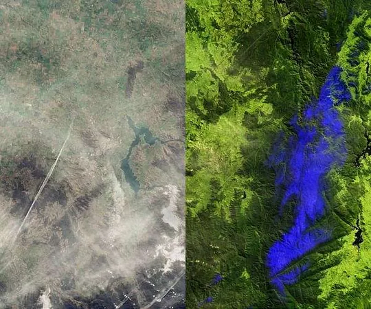
In an exciting breakthrough for meteorology and environmental science, recent images captured by the Copernicus Sentinel-2 mission are revolutionizing our understanding of two commonly confused natural phenomena: snow and clouds. These advancements, showcased in images taken in August 2024 of the Australian Alps, demonstrate how cutting-edge satellite technology can discern these elements with remarkable precision.
Technology Behind the Breakthrough
The satellites are equipped with sophisticated multispectral imagers that can record optical images across 13 distinct spectral bands, ranging from visible light to shortwave-infrared wavelengths.
Visualizing the Differences
In the first image, which displays the scene in true color, we see a striking visual that mirrors what the human eye perceives—an expansive landscape dominated by clouds with visible aircraft contrails along the busy Canberra-Melbourne flight route. Both snow-covered areas and clouds appear similarly white, leading to confusion for observers.
However, the magic happens in a second image processed using false-color techniques that incorporate shortwave-infrared bands. In this visualization, snow and ice stand out in a vivid electric blue, while clouds retain their white appearance. The differentiation allows viewers to see thinner cloud formations and contrails faintly, establishing a clear contrast between the bright, enduring snow and the ethereal clouds overhead.
Implications of the Findings
This level of distinction is not just academically fascinating; it holds significant implications for satellite imaging processes. As artificial intelligence (AI) technologies continue to evolve, the applications for this kind of imagery expand exponentially. AI algorithms can utilize the advanced multispectral data from the Copernicus Sentinel-2 mission to improve the classification of environmental features, enhancing weather prediction models, climate monitoring, and even disaster management planning.
The Future of Satellite Imaging
As satellite imaging technologies develop further, the potential for greater insights into our planet’s dynamics grows. This innovation marks a critical step in understanding our environment better, helping scientists and researchers tackle challenges posed by climate change and weather variability. It's evidence of how technology is not just observing but profoundly enhancing our comprehension of the world around us.
Conclusion
Stay tuned as we continue to explore the fascinating intersection of technology and nature!


 Brasil (PT)
 Canada (EN)
 Chile (ES)
 Česko (CS)
 대한민국 (KO)
 España (ES)
 France (FR)
 Hong Kong (EN)
 Italia (IT)
 日本 (JA)
 Magyarország (HU)
 Norge (NO)
 Polska (PL)
 Schweiz (DE)
 Singapore (EN)
 Sverige (SV)
 Suomi (FI)
 Türkiye (TR)
 الإمارات العربية المتحدة (AR)