Unveiling Earth's Geological Mysteries: The Cutting-Edge Maps Transforming Geoscience
2024-12-25
Author: Arjun
Unveiling Earth's Geological Mysteries: The Cutting-Edge Maps Transforming Geoscience
The Earth is a constantly evolving entity with a surface teeming with geological features and active tectonic processes that have developed over billions of years. Understanding the intricate interactions between these elements is not only essential for unraveling the planet’s history but also for predicting its future. A groundbreaking study has recently emerged, showcasing a remarkable leap forward in this field by combining advanced geoscientific data with innovative technology to generate comprehensive maps that offer unprecedented insight into Earth's geological and tectonic structure.
The Dynamic Dance of Tectonic Plates
Unlike a single, rigid shell like that of an egg, Earth's crust is fragmented into multiple rigid sections known as tectonic plates. These plates are not static; they float atop the mantle and are propelled by convection currents of molten magma beneath. Although their movement is imperceptibly slow—akin to the growth rate of fingernails—over millions of years, these shifts can reshape continents and oceans in astonishing ways.
Historically, Earth was once unified as the supercontinent Pangea before its landmasses fragmented into Laurasia and Gondwana, evolving into the continents we recognize today. Fast forward another 100 million years, and our planet's configuration will be unrecognizable once again, hinting at the expansive timelines at play in geological processes.
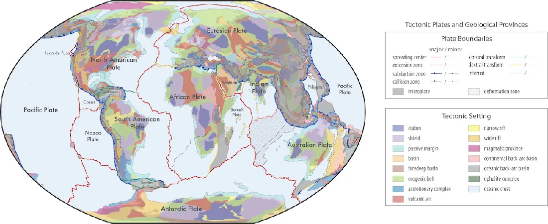
Understanding the structural architecture and tectonic environments of Earth's surface rocks is essential for geoscientists. This recent study has introduced a groundbreaking compilation of tectonic plate boundaries and geological provinces, available in a vector shapefile format. This cutting-edge model seamlessly integrates interpretive data such as crust type, plate configuration, province classification, and the chronology of the most recent orogenies, paving the way for refined geoscientific analyses.
Innovative Data Models for a Better Understanding
These innovative global models emerge from the meticulous amalgamation of varied geological, geochemical, and geochronological data. Researchers have refined existing frameworks by employing diverse constraints, including GPS motion tracking, earthquake data, mapped faults, and geochronological insights. The result is not only heightened accuracy for plate and province boundaries but also a richer depiction of the complex geological processes that shape our planet.
GPS data is sourced from specialized observatories yielding precise measurements of tectonic plate movements. Geochronology provides age determinations for tectonic plates—revealing the birth, evolution, and demise of these structures—while mapping geological faults unveils crucial clues about past geological events and transformations. By piecing together these elements, scientists can project future evolutionary trends in Earth’s geophysical landscape.
The study highlights two fundamental models that promise to redefine geoscientific research: 1. **Global Geologic Provinces:** These spatially accurate maps unify common geological characteristics, essential for broad comparative studies and precise plate reconstructions. 2. **Present-Day Plate Boundaries:** This enhanced model extends tectonic boundary mapping back around 2.3 billion years, integrating a multitude of geological interpretations and observations, revolutionizing our comprehension of Earth's geodynamic processes.
Open-Source Revolution in Geoscience
The implications of these models extend beyond academic research; they are set to become a new standard in classifying geological data across diverse databases. Additionally, the models are freely accessible and open-source, inviting ongoing updates and enhancements from the global geoscientific community. This collaborative approach fosters an interactive environment essential for advancing our understanding of Earth’s geological past, especially during the Mesoproterozoic era and significant periods prior.
The transition from traditional raster maps to vector format shapefiles represents a significant innovation. This modern approach allows for the seamless integration of geological data, ensuring nuanced and sophisticated representations of Earth's geological features. Each geometric entity within these maps can possess multiple unique attributes, enabling a detailed exploration of the complex interrelationships that define our planet's geological framework.
In summary, this pioneering work not only sets the foundation for more accurate and comprehensive geological and tectonic models but also marks a vital step toward enhancing our predictive capabilities regarding Earth's future. These revolutionary maps stand as dynamic tools, built to evolve with contributions from the worldwide scientific community. By making these resources available to all, the study cultivates a collaborative approach to further refining our understanding of Earth's geological mysteries, ensuring a healthier relationship with our planet for generations to come.
Discover the Future of Earth Science!
Join the wave of innovation and exploration as these models transform our understanding of the world beneath our feet!


 Brasil (PT)
 Canada (EN)
 Chile (ES)
 España (ES)
 France (FR)
 Hong Kong (EN)
 Italia (IT)
 日本 (JA)
 Magyarország (HU)
 Norge (NO)
 Polska (PL)
 Schweiz (DE)
 Singapore (EN)
 Sverige (SV)
 Suomi (FI)
 Türkiye (TR)