Unprecedented Stratospheric Warmth Above Antarctica: What This Means for Our Climate
2024-09-16
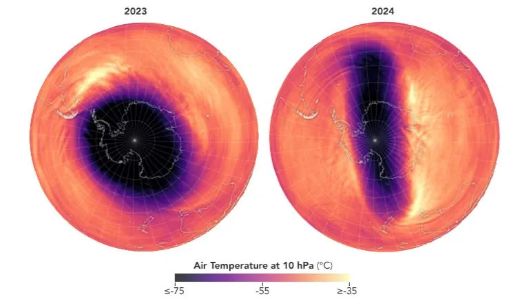
Recent observations from NASA have unveiled a shocking phenomenon: the stratosphere above Antarctica experienced an unprecedented spike in temperature this July, marking the earliest instance of such warming recorded since monitoring began.
Atmospheric scientists, including Lawrence Coy and Paul Newman from NASA's Global Modeling and Assimilation Office, have been meticulously analyzing this critical region of our atmosphere, which ranges from approximately 4 to 31 miles above the Earth's surface. Their research has revealed significant anomalies in the stratospheric temperatures during the Southern Hemisphere's winter season.
Typically, the stratospheric temperature at around 19 miles high hovers at a frigid minus 112 degrees Fahrenheit (minus 80 degrees Celsius). However, on July 7, this baseline shattered with a remarkable leap of 27 degrees Fahrenheit, soaring to minus 85 degrees Fahrenheit (minus 65 degrees Celsius). This extraordinary event has set a new record for the warmest July temperature ever documented in the stratosphere above Antarctica, surprising many in the scientific community.
Coy commented, "This July event marked the earliest stratospheric warming ever seen in our 44-year record." The unusual warm spell persisted for two weeks before temperatures dipped back down on July 22, only to surge again to 31 degrees Fahrenheit (minus 1 degrees Celsius) on August 5.
Understanding the dynamics of the polar vortex is essential for interpreting these events. The stratosphere's weather patterns are typically driven by westerly winds that can reach speeds of around 200 mph, forming what is known as the polar vortex. However, disruptions can occur, causing the vortex to stretch and weaken, leading to significant warming trends in the Antarctic stratosphere.
Interestingly, such sudden warming in Antarctica occurs significantly less frequently than its Arctic counterpart—about once every five years. This discrepancy is attributed to the differences in landmass; the Northern Hemisphere's larger land area can impact wind flows in the troposphere, leading to weather systems that can influence the polar vortex more drastically.
Moreover, July's tropospheric weather conditions aligned with previous trends, tying with July 1991 as the fifth warmest July on record for the region. However, experts caution that the connection between stratospheric warming and surface weather patterns is not straightforward.
Newman explained, "Variations in sea surface temperatures and sea ice can disturb these large-scale atmospheric systems, but pinpointing the reasons behind their development is complex."
As the impacts of climate change unfold, these extreme weather patterns serve as crucial indicators of shifts in our global climate system. Scientists are keenly aware that continued monitoring and understanding of events like these are vital to predict future climatic trends and their potential repercussions on ecosystems and human societies.
Stay tuned for more updates as we unravel the mysteries behind this remarkable warming event above Antarctica and its implications on our planet's climate system!


 Brasil (PT)
 Canada (EN)
 Chile (ES)
 España (ES)
 France (FR)
 Hong Kong (EN)
 Italia (IT)
 日本 (JA)
 Magyarország (HU)
 Norge (NO)
 Polska (PL)
 Schweiz (DE)
 Singapore (EN)
 Sverige (SV)
 Suomi (FI)
 Türkiye (TR)