Unlocking Secrets of Sea Level Rise: How Vintage Aerial Photos Are Changing the Game
2025-07-03
Author: Wei
On November 28, 1966, a U.S. Navy plane flew over the Antarctic Peninsula, capturing more than just breathtaking landscapes. A photographer documented a pivotal moment involving the Wordie Ice Shelf, which, unbeknownst to them, would dramatically disappear in just 30 years.
This catastrophic collapse unleashed a torrent of glacial ice, breaking the natural barrier that held vast amounts of glacier ice back from the sea, allowing it to drift freely and contribute to rising sea levels.
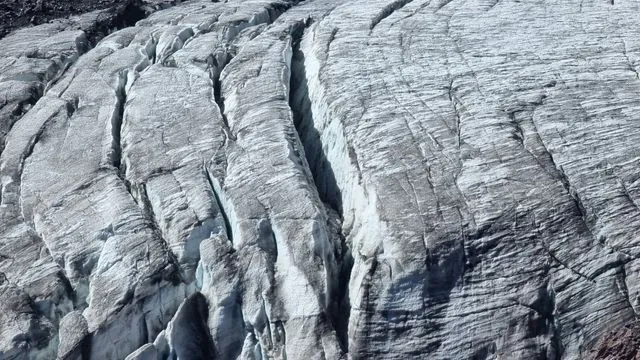
The Role of Ice Shelves in Global Sea Level Rise
Ice shelves serve as crucial brakes on glaciers that flow toward the ocean. When these ice shelves crumble away, the glaciers lose their support, leading to accelerated melting and floating into warmer waters. While the ice shelves themselves might not significantly impact sea levels, the glacier ice they hold back most certainly does.
Interestingly, even though Antarctica feels worlds away, its ice melt affects sea levels in distant places like Denmark. The gravitational forces shift as ice melts, causing sea levels to rise disproportionately in northern regions.
The Wordie Ice Shelf, although small, exemplifies the potential threat of larger ice shelves like the Ronne and Ross, which could result in a staggering five-meter rise in sea levels if they collapse.
A Groundbreaking Study Using Vintage Photos
A recent study by researchers at the University of Copenhagen has harnessed this historic 1966 photo as a critical data point. Their research, now published in *Nature Communications*, combines vintage aerial images with cutting-edge satellite observations to chart the gradual collapse of the Wordie Ice Shelf over decades.
Postdoc Mads Dømgaard, the lead author, emphasized that the findings will refine computer models related to sea level change, improving predictions and guiding climate change adaptation strategies effectively.
Revolutionary Insights from Historical Images
Utilizing a technique called structure-from-motion photogrammetry, researchers meticulously analyzed hundreds of historical aerial photos from 1966 to 1969. This method allows for precise 3D reconstruction of ice thickness, surface changes, and flow dynamics over time.
Their findings challenged previous assumptions about the main culprits behind the ice shelf's collapse. Instead of a warming atmosphere or icy meltwater lakes, researchers noted that rising sea temperatures and melting beneath the ice are the primary drivers of Wordie’s decline.
What This Means for Our Future
These revelations turn prior understandings of ice shelf collapses on their heads. Co-author Anders Anker Bjørk noted that collapses may occur more gradually than previously feared, suggesting that while immediate catastrophic sea level rises might be slower, the longer processes present a risk for future scenarios.
This extended timeline complicates efforts to reverse ice cap melting once it begins, sending a clear message: we must prioritize reducing greenhouse gas emissions now, before the ice sheets reach irreversible tipping points.
In a nutshell, the legacy of a long-lost photograph is not just a glimpse into the past but a crucial key to understanding our planet's precarious future as we face the realities of climate change.


 Brasil (PT)
 Canada (EN)
 Chile (ES)
 Česko (CS)
 대한민국 (KO)
 España (ES)
 France (FR)
 Hong Kong (EN)
 Italia (IT)
 日本 (JA)
 Magyarország (HU)
 Norge (NO)
 Polska (PL)
 Schweiz (DE)
 Singapore (EN)
 Sverige (SV)
 Suomi (FI)
 Türkiye (TR)
 الإمارات العربية المتحدة (AR)