Unlocking Satellite Imagery: A Game Changer for Global Food Security
2025-04-30
Author: Wei
Revolutionizing Research for Sustainable Development Goals
A bold new proposal in the *Proceedings of the National Academy of Sciences* advocates for opening up commercial satellite image archives to supercharge research supporting the United Nations' Sustainable Development Goals (SDGs). Access to high-resolution satellite imagery is pivotal, particularly for monitoring smallholder farms in low- and middle-income countries, which play a critical role in global food security.
The Unsung Heroes of Food Production
Did you know that smallholder farmers—who often manage less than two hectares—contribute over 30% of the world's food supply? However, their farming practices remain poorly documented, largely due to the prohibitive costs of very high-resolution (VHR) satellite imagery, which can be as steep as 2 euros per square kilometer. Felicia O. Akinyemi, an Associate Professor of Geomatics at Karlstad University, highlights this urgent need for accessible data to enhance productivity and documentation.
Why Open Data is a Game Changer
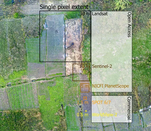
Successful initiatives like the US Landsat and the EU Copernicus demonstrate how open satellite data spark innovation in sustainability research. The researchers believe that enabling access to VHR data for non-commercial research would significantly enhance the ability to monitor smallholder farming, directly impacting various sustainability initiatives, including the critical Goal 2: Zero Hunger.
Addressing the Challenges of Monitoring Smallholder Farms
However, monitoring smallholder farms presents unique challenges. A major roadblock is the lack of field-verified data essential for effective machine learning algorithms. Without accurate training datasets, predictions can become unreliable. Furthermore, the typically small sizes of these farms—often ranging from less than 0.25 hectares up to 5 hectares—render many publicly available satellite images too low in resolution to effectively identify crop types, especially in intercropped conditions.
Akinyemi’s Pioneering Research in West Africa
Akinyemi’s work is pivotal in addressing these challenges, aligning with development goals about sustainable agriculture and Goal 15.3, which focuses on land degradation neutrality. Her research, supported by the EU Marie Skłodowska-Curie Individual Fellowship in 2022, aims to map monocultures and intercropping practices in maize and cassava within Nigeria's Guinea Savanna during two growing seasons.
Harnessing Satellite Data for Future Resilience
To tackle issues like frequent cloud cover during the growing season, Akinyemi’s team combines data from Sentinel-2 and Sentinel-1 radar, allowing for nuanced analysis of spectral-temporal patterns on a monthly and bi-monthly basis. Imagine the insights gained from using sub-meter resolution satellite images!
Deepening Our Understanding of Agricultural Adaptation
A pilot study in southwestern Nigeria not only examines how land use changes affect farming resilience amid climate shifts but also integrates local stakeholders' perspectives on future land use. This multifaceted approach fosters a richer understanding of how to bolster agricultural adaptability, vital for ensuring food security in a changing world.


 Brasil (PT)
 Canada (EN)
 Chile (ES)
 Česko (CS)
 대한민국 (KO)
 España (ES)
 France (FR)
 Hong Kong (EN)
 Italia (IT)
 日本 (JA)
 Magyarország (HU)
 Norge (NO)
 Polska (PL)
 Schweiz (DE)
 Singapore (EN)
 Sverige (SV)
 Suomi (FI)
 Türkiye (TR)
 الإمارات العربية المتحدة (AR)