Shocking Discovery: Satellite Captures 9-Day Tsunami in Greenland – What Researchers Found Will Leave You Breathless!
2024-11-01
Author: Yu
In a stunning revelation, a satellite flying over Greenland last year captured extraordinary images of a tsunami that hit the Dickson Fjord, creating chaos for an astonishing nine days. This event, triggered by a massive rockslide, has left scientists fascinated, offering new insights into the Earth's geological dynamics.
The September 2023 tsunami unleashed a mighty force, as around 880 million cubic feet (25 million cubic meters) of ice, rock, and sediment plunged into the fjord. The result? A relentless sloshing of waters every 90 seconds for more than a week, contained by the towering 6,000-foot (1,830-meter) walls of the fjord. Researchers from a recent publication in Science detail how this seismic event turned the fjord into a dynamic waterway that didn’t just ripple but made the Earth shake.
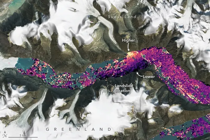
As the fierce waves battered the fjord, NASA and France's Centre National d’Études Spatiales (CNES) operated the Surface Water and Ocean Topography satellite (SWOT) directly overhead. This satellite not only documented the ordeal but also provided unprecedented data about the tsunami's impact on water levels in the 1,772-foot-deep (540-meter-deep) fjord.
Josh Willis, a sea-level researcher from NASA’s Jet Propulsion Laboratory, noted the significance of the satellite's timing: “SWOT happened to fly over at a time when the water had piled up pretty high against the north wall of the fjord,” he explained. The satellite's observations showed that water levels on the north side surged up to four feet (1.2 meters) higher than those on the south side, creating a striking imbalance.
Using advanced interferometry techniques, SWOT's precision tools allowed scientists to measure these changes with remarkable accuracy. This technology is often utilized in various scientific fields to hone in on minuscule differences in measurements, including investigations into spacetime itself.
"This is groundbreaking," said Lee-Lueng Fu, SWOT's project scientist. "The KaRIn radar’s resolution was fine enough to make observations between the relatively narrow walls of the fjord. Conventional altimeters simply cannot achieve the precision needed for such a small-scale event."
As experts continue to analyze the data, the implications of this tsunami reach far beyond Greenland. They could offer insights into similar geological phenomena worldwide, helping scientists to predict and potentially mitigate the impacts of future tsunamis and rockslides.
Stay tuned as we explore more about how technology is shining a light on previously hidden natural disasters and what the future holds for geological research! This astonishing event has raised questions and speculations that may change our understanding of the Earth’s powerful forces—make sure you don’t miss the latest findings!


 Brasil (PT)
 Canada (EN)
 Chile (ES)
 España (ES)
 France (FR)
 Hong Kong (EN)
 Italia (IT)
 日本 (JA)
 Magyarország (HU)
 Norge (NO)
 Polska (PL)
 Schweiz (DE)
 Singapore (EN)
 Sverige (SV)
 Suomi (FI)
 Türkiye (TR)