Revolutionizing Ionospheric Mapping: How Your Smartphone Could Enhance GPS Accuracy!
2024-11-14
Author: Li
Introduction
A groundbreaking study published in *Nature* reveals that aggregated data from millions of smartphone users could significantly enhance our understanding of the Earth's ionosphere. This advancement has the potential to improve global positioning systems (GPS) dramatically.
Understanding the Ionosphere
The ionosphere, the upper layer of Earth’s atmosphere, is rich in free electrons and plays a crucial role in the propagation of radio waves. Its behavior is heavily influenced by solar activity and geomagnetic storms. As a result, the speed at which radio waves—from satellites reaching Earth—travel can vary, ultimately affecting the precision of GPS technologies.
Importance of Monitoring Electron Concentration
Monitoring electron concentration within the ionosphere is vital for correcting discrepancies in wave speeds. Traditional mapping methods using ground-based Global Navigation Satellite System (GNSS) receivers often leave gaps in coverage, limiting our understanding of the ionosphere’s dynamics.
Innovative Approach by Brian Williams
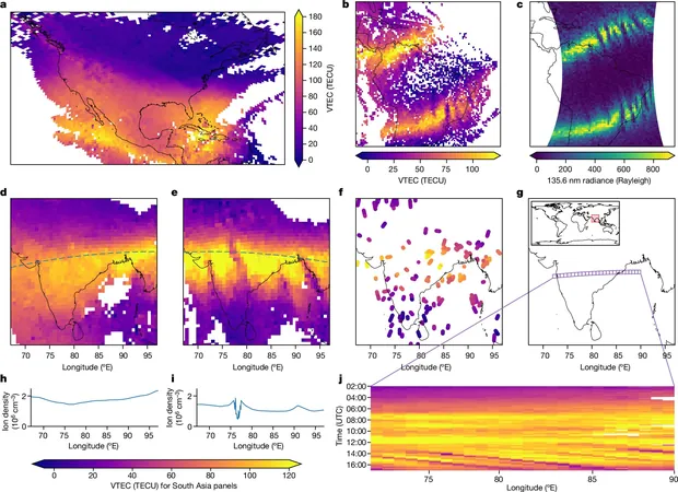
Enter Brian Williams and his research team, who harnessed data derived from millions of Android smartphones to create a more comprehensive map of the ionosphere. They achieved a remarkable feat—doubling the coverage that conventional ground-based receivers provide. Many modern Android devices are equipped with dual-frequency GNSS receivers, capable of producing measurements similar to those of large, stationary GNSS systems.
Correlation Between Smartphone Data and Traditional Methods
By comparing the ionosphere maps created from data collected via approximately 40 million smartphones each day to those generated by 9,000 GNSS receivers over a two-month span in 2023, the researchers observed a striking correlation between the two datasets. This correlation suggests that smartphone data can effectively complement and enhance existing mapping techniques.
Regional Density and Mapping Precision
Interestingly, the study found that smartphone usage provides greater density in regions such as Eastern Europe, India, South Asia, and parts of South America and Africa. This increased coverage could lead to more precise mapping in those areas, potentially revolutionizing GPS applications and making them more reliable in regions previously prone to inaccuracies.
Limitations and Challenges
However, it’s crucial to recognize some limitations of this technology. The smaller and less advanced components in smartphones compared to robust GNSS ground-based arrays might introduce additional measurement noise, posing a challenge to the overall accuracy of the data.
Broader Implications of the Research
The implications of this research extend beyond just better GPS; it opens up pathways for more detailed studies in atmospheric science and disaster management, as well as enhancing various technologies that rely on accurate positioning. The future of global navigation could very well depend on the devices we carry in our pockets every day!
Future Prospects
What will be the next steps in using smartphones for scientific advancements? Stay tuned to find out how this technology evolves!

 Brasil (PT)
 Canada (EN)
 Chile (ES)
 España (ES)
 France (FR)
 Hong Kong (EN)
 Italia (IT)
 日本 (JA)
 Magyarország (HU)
 Norge (NO)
 Polska (PL)
 Schweiz (DE)
 Singapore (EN)
 Sverige (SV)
 Suomi (FI)
 Türkiye (TR)