Revolutionizing Forest Recovery: How Satellite Technology is Transforming Post-Wildfire Assessment
2025-07-07
Author: Arjun
Satellite Insights on Forest Recovery Post-Wildfire
In a groundbreaking study, researchers are harnessing satellite technology to unveil the secrets of forest recovery after devastating wildfires, potentially changing how land management practices are evaluated and executed.
A Cost-Effective Approach
Published in the journal *Fire*, the findings from the U.S. National Science Foundation National Center for Atmospheric Research (NSF NCAR) reveal a revolutionary method of assessing recovery using images from NASA satellites. This innovative technique, combined with data from the U.S. Geological Survey (USGS), provides an unprecedented view into how effectively forests bounce back after wildfires and the rate of recovery across various land management strategies.
"We’ve developed a simple framework that empowers fire and land managers to visually understand what methods truly enhance forest recovery post-wildfire," shared Shima Shams, lead author of the study. "This quick and cost-effective approach informs managers where to allocate funds for maximum impact."
Feeding on Data
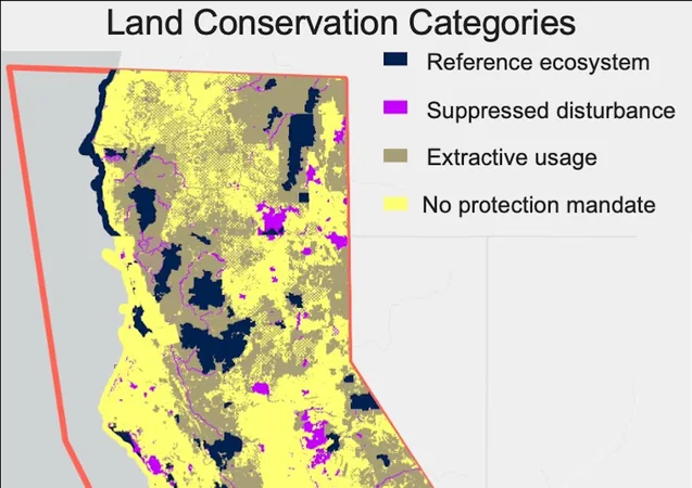
Focusing on Northern California and Southern Oregon—regions notorious for their escalating wildfire incidents—the research team began by pinpointing wildfire occurrences using the Moderate Resolution Imaging Spectroradiometer (MODIS) aboard NASA’s satellites. They then monitored how vegetation recovered five years post-fire by utilizing imagery from the Landsat mission, which has been tracking Earth’s land surface since 1984.
By merging their findings with the USGS's Protected Areas Database, they were able to categorize land conservation strategies and analyze recovery rates correlated to these practices.
The Recovery Roll Call
Their results were telling: unprotected areas struggled, showing only a 27% recovery rate after five years compared to 37% for areas with some form of protection. Notably, those lacking conservation measures also faced more severe fire damage, with burn intensity being 25-47% higher, revealing the critical importance of strategic land management in reducing damage and fostering regrowth.
Diverse Impacts by Forest Type
The study also shed light on how recovery rates varied by forest type, highlighting that evergreen forests reaped the most benefits from protective measures. These insights can significantly aid management policies by identifying which forest types require targeted conservation strategies.
Collaboration is Key
While the satellite resolution might not capture the fine details, such as the presence of invasive species in regrowth, the framework provides a cost-efficient overview that can guide decision-making. Future research may delve into biodiversity inclusion in regions lacking protection.
The NSF NCAR team aims to collaborate with local land and fire managers to tailor this framework to specific needs, enhancing understanding of effective recovery practices and prioritizing successful interventions.
"Detailed assessments are vital for managers to evaluate the effectiveness of their strategies and adjust accordingly," Shams noted. "Remote sensing offers a valuable big-picture perspective to highlight the efficacy of implemented practices."

 Brasil (PT)
 Canada (EN)
 Chile (ES)
 Česko (CS)
 대한민국 (KO)
 España (ES)
 France (FR)
 Hong Kong (EN)
 Italia (IT)
 日本 (JA)
 Magyarország (HU)
 Norge (NO)
 Polska (PL)
 Schweiz (DE)
 Singapore (EN)
 Sverige (SV)
 Suomi (FI)
 Türkiye (TR)
 الإمارات العربية المتحدة (AR)