Revolutionary High-Resolution Rice Map Unveiled: A Game-Changer for Africa's Food Security
2025-06-25
Author: Ming
Groundbreaking High-Resolution Rice Map Released
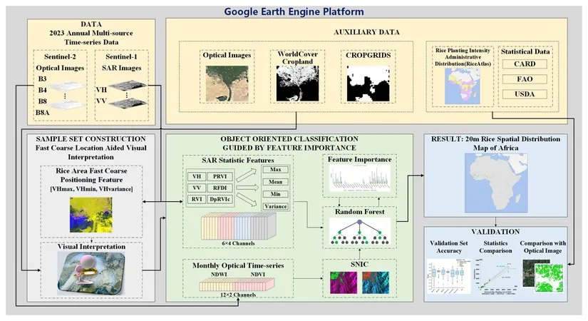
In a groundbreaking initiative, scientists from the Aerospace Information Research Institute (AIR) of the Chinese Academy of Sciences have unveiled Africa's very first high-resolution rice distribution map, boasting a striking 20-meter resolution. Released as part of their 2023 research published in Earth System Science Data, this extensive dataset covers countries across Africa with rice cultivation areas exceeding 5,000 hectares.
Unlocking Potential to Combat Hunger
This pioneering study showcases an impressive classification accuracy of over 85%, with an astounding linear correlation (R²) exceeding 0.9 when compared to national statistics, enhancing its reliability. The dataset will be available to researchers worldwide, crucial for advancing the United Nations Sustainable Development Goal 2 (SDG2), aimed at achieving zero hunger.
Rice: A Staple Crop Under Pressure
Rice is Africa’s third most essential staple crop, playing a vital role in the continent’s fight for food security. Despite contributing a mere 4.7% to global rice production, Africa’s demand for this critical grain is skyrocketing, growing at an annual rate of over 6%, which outstrips other staple crops. Countries across Africa are responding by expanding their cultivated land by an astonishing average of 400,000 hectares each year over the past 30 years.
Innovations to Boost Rice Production
In 2023, the Africa Rice Center championed the "2030 Africa Rice Research and Innovation Strategy" aimed at amplifying rice production across the continent. However, significant challenges loom large, including climate change impact, urban growth, and deforestation.
Mapping Challenges Amidst Diversity
Mapping rice cultivation across Africa is no small feat, largely due to the continent's unique climate and diverse planting seasons. The reliance on rainfed rice creates complications, as it lacks the flood indicators typical in irrigated environments, making phenological mapping a daunting task. Thus, a fusion of time-series data with advanced supervised classification has emerged as the go-to method for rice distribution mapping.
Innovative Solutions for Precision Mapping
Existing rice distribution products are inadequate, often presenting low resolution (greater than 5 km), which obstructs the accurate identification of rice cultivation zones. The complexity of varied terrains and farming practices compounds these mapping hurdles.
To tackle these pressing issues, the research team has devised a pioneering approach that harmonizes dual-polarimetric SAR backscattering features with cutting-edge machine learning algorithms. Their innovative framework, dubbed "backscatter-based coarse localization followed by multi-source time-series refined classification," facilitates precise mapping in regions characterized by diverse planting cycles and rainfed systems. This initiative incorporates an object-oriented feature importance classifier, marking a leap beyond conventional optical mapping techniques.
A Step Towards Sustainable Agriculture
This high-resolution rice map not only enhances our understanding of rice distribution in Africa but also positions itself as a crucial tool in the quest for sustainable agriculture, ensuring that rising demands are met while safeguarding the continent's food future.


 Brasil (PT)
 Canada (EN)
 Chile (ES)
 Česko (CS)
 대한민국 (KO)
 España (ES)
 France (FR)
 Hong Kong (EN)
 Italia (IT)
 日本 (JA)
 Magyarország (HU)
 Norge (NO)
 Polska (PL)
 Schweiz (DE)
 Singapore (EN)
 Sverige (SV)
 Suomi (FI)
 Türkiye (TR)
 الإمارات العربية المتحدة (AR)