Revolutionary High-Res Maps Unleash Targeted Mosquito Control in Rio de Janeiro!
2025-06-06
Author: Li
Unlocking the Secrets of Mosquito Breeding Grounds
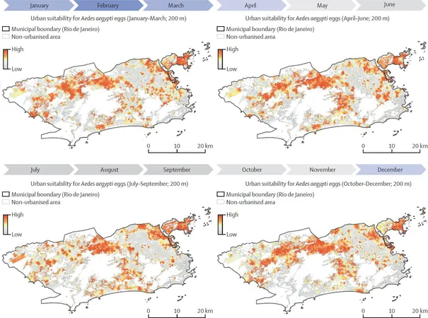
In a groundbreaking effort to combat the notorious Aedes aegypti mosquito, known for spreading diseases like dengue fever and Zika, geoinformation scientist Dr. Steffen Knoblauch has unveiled a game-changing high-resolution environmental suitability map for Rio de Janeiro, Brazil. This innovative tool pinpoints the areas most favorable for mosquito breeding, paving the way for effective control strategies.
Harnessing the Power of Geospatial Data
Utilizing cutting-edge geospatial big data methods and freely available geodata—including satellite imagery, street views, and climate information—Dr. Knoblauch, from Heidelberg University’s Interdisciplinary Center for Scientific Computing, has transformed how we approach mosquito management. His findings, published in The Lancet Planetary Health, reveal how we can now tackle this public health challenge with precision.
The Mosquito Menace: Why It Matters
The Aedes aegypti, often dubbed the Egyptian tiger mosquito, is infamous for breeding in stagnant water found in everyday items like discarded tires and potted plants. With urbanization on the rise, these breeding habitats are expanding, complicating efforts to control these disease carriers—especially given the limited availability of vaccines for the diseases they transmit.
Precision Mapping: The Key to Control
Dr. Knoblauch emphasizes that accurate maps detailing Aedes aegypti's suitability are crucial for effective vector control, particularly in diverse urban environments. Traditional monitoring methods struggle to measure the mosquito's unpredictable presence, as it typically flies no further than 1,000 meters without wind assistance.
A New Era of Mosquito Monitoring
By harnessing openly available geodata, Dr. Knoblauch's research revealed that such data can account for an impressive 75% of the variability in mosquito presence observed in samples collected in Rio. Through advanced spatio-temporal modeling and Geospatial Artificial Intelligence (GeoAI), he identified 79 environmental indicators relevant to Aedes aegypti, including breeding container density and urban climate conditions.
A Game-Changer for Urban Pest Control
The result? The world's first spatially continuous environmental suitability map for Aedes aegypti, providing vital insights for targeted interventions in urban hotspots. This novel approach not only enhances local mosquito control efforts but can also be replicated in similar environmental conditions worldwide.
Predicting the Future of Mosquito Breeding
As Dr. Knoblauch puts it, combining robust geodata with entomological surveillance enables us to predict mosquito breeding sites with unparalleled accuracy. This breakthrough heralds a new chapter in the fight against mosquito-borne diseases, equipping communities with the tools needed to protect their health.


 Brasil (PT)
 Canada (EN)
 Chile (ES)
 Česko (CS)
 대한민국 (KO)
 España (ES)
 France (FR)
 Hong Kong (EN)
 Italia (IT)
 日本 (JA)
 Magyarország (HU)
 Norge (NO)
 Polska (PL)
 Schweiz (DE)
 Singapore (EN)
 Sverige (SV)
 Suomi (FI)
 Türkiye (TR)
 الإمارات العربية المتحدة (AR)