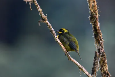
Revolutionary Bird Mapping Techniques Set to Transform Conservation in Colombia
2024-10-23
Author: Mei
Revolutionary Bird Mapping Techniques Set to Transform Conservation in Colombia
Colombia, renowned for being the most avian-diverse country on the planet, is taking a bold step forward in the realm of bird conservation. Led by Natalia Ocampo-Peñuela, an assistant professor of environmental studies, a collaborative team of Colombian researchers has unveiled groundbreaking mapping techniques that leverage community science data and advanced modeling techniques to detail bird species distributions across the nation.
The landmark study, published openly in the journal Diversity and Distributions, reveals exceptionally high-resolution maps that delineate the range and Area of Habitat (AOH) for nearly all terrestrial bird species in Colombia, encompassing both endemic and threatened species. Impressively, these maps cover an astonishing 94 percent of Colombia’s resident terrestrial bird species, equipping conservationists with vital tools to guide efforts in one of the world's richest biodiversity hotspots.
Andres Felipe Suarez-Castro, a lecturer at Griffith University in Australia and the study's lead author, stated, “Despite our status as the most bird-diverse country globally, our knowledge of many species' distributions is still quite limited.” The researchers highlighted the inadequacies of current global maps, which often lack the required precision for effective local conservation strategies. Nonetheless, with the wealth of open-access data available today, the integration of ecological insights with community science records has significantly enhanced their understanding of bird distributions in Colombia.
The importance of accurate species distribution maps cannot be overstated for informed conservation decision-making, assessment of extinction risks, and the safeguarding of biodiversity. Unfortunately, traditional mapping methods often do not provide the granularity necessary for local initiatives. Ocampo-Peñuela’s team tackled this challenge by synthesizing expert-drawn maps with probabilistic modeling and community contributions via eBird, a global database where bird enthusiasts report their sightings. The outcome is an unprecedentedly detailed illustration of Colombia’s biodiversity, particularly in regions like the Andean-Amazon transition zone and the Chocó region.
These maps paint a vivid picture of species richness and highlight biodiversity hotspots that previously received little attention due to historical conflicts or accessibility issues. Ocampo-Peñuela noted the urgency of these insights, especially concerning the alarming rates of deforestation occurring in these regions, which serve as habitats for numerous endemic species that cannot be found anywhere else in the world.
To fill the knowledge gaps in critical regions like the Amazon and the Darién Gap, the researchers are advocating for enhanced participation from local communities. They believe that by empowering local residents to take part in biodiversity monitoring efforts, Colombia can bolster its conservation strategies without always relying on external experts. Ocampo-Peñuela pointed out the issue of "parachute science"—temporary interventions by outsiders that fail to engage local knowledge and long-term solutions.
The repercussions of this innovative mapping extend beyond local conservationists to national policymakers, as Colombia prepares to host COP16, a pivotal moment for global biodiversity discussions. With an ambition to protect 30 percent of the Earth’s land and oceans by 2030, reliable mapping data will be fundamental to achieving these ambitious conservation goals.
Moreover, Ocampo-Peñuela's open-source mapping framework serves as an inspiring model for researchers in other biodiversity-rich nations, encouraging them to utilize local data for similar initiatives.
“The value of our work isn't just in the accuracy of the maps,” she remarked. "It’s also in the transparency regarding where we have solid information and where uncertainties lie. Each pixel conveys a level of certainty, which is empowering for decision-makers trying to navigate data gaps."
This revolutionary mapping solution is accessible worldwide, enabling researchers to continuously refine it as new data comes in, nurturing a dynamic resource for conservation efforts. Its adaptable nature means it could be employed across various taxa and ecosystems beyond Colombia, extending to other flora and fauna.
Not only do Ocampo-Peñuela and her team have high aspirations for these maps in elevating Colombia's presence in global conservation science, but they also hope their work will galvanize other nations to invest in research designed to empower local scientists and conservationists. "We take immense pride in the fact that this research has been conducted by Colombians for Colombians,” Ocampo-Peñuela asserted.
As the team continues to enhance these mapping methodologies, they remain staunch advocates for conservation initiatives that balance scientific rigor with community engagement, ensuring that ecological needs at local levels are addressed in tandem with global biodiversity commitments.
“This study underscores the significance of integrating various data sources to enrich our understanding of bird diversity,” said Suarez-Castro. "Community science is vital, and we must cultivate partnerships with local stakeholders to gather critical insights that lead to effective biodiversity protection."
Colombia's trailblazing work in bird conservation serves not only as a beacon of hope for the planet's ecosystems but also as a call to action for a more inclusive, innovative, and collaborative approach to environmental stewardship.


 Brasil (PT)
 Canada (EN)
 Chile (ES)
 España (ES)
 France (FR)
 Hong Kong (EN)
 Italia (IT)
 日本 (JA)
 Magyarország (HU)
 Norge (NO)
 Polska (PL)
 Schweiz (DE)
 Singapore (EN)
 Sverige (SV)
 Suomi (FI)
 Türkiye (TR)