Revolutionary AI Paves the Way for Accurate Weather Forecasting!
2025-09-20
Author: Yu
Unlocking Secrets of Earth's Atmosphere with AI
Predicting extreme weather events is no walk in the park—meticulous humidity data is crucial. But guess what? A groundbreaking study has just unveiled the world’s first high-resolution Global Navigation Satellite System (GNSS) troposphere tomography driven by Artificial Intelligence (AI). This is a game changer!
AI's Superpowers: Sharper 3D Humidity Maps!
By harnessing the Super-Resolution Generative Adversarial Network (SRGAN), scientists have transformed coarse atmospheric data into crystal-clear 3D humidity maps, slashing forecasting errors by over 50% in some instances. This remarkable enhancement captures the minute details of small-scale weather phenomena—crucial for forecasting severe weather events.
Bridging Science and Transparency
Not only is the accuracy of predictions improving, but this innovative method also clarifies where AI focuses its predictions, shedding light on its decision-making process. By merging satellite signals with cutting-edge learning algorithms, the new approach promises more reliable local weather forecasts—essential for human safety!
The Evolution of Weather Forecasting
For over a century, our ability to predict weather has evolved from simple chalkboard equations to complex computer simulations. Yet one major challenge remains: effectively capturing small-scale events like torrential rains or vigorous storm fronts.
Tackling Gaps in Data
Old GNSS tomographic techniques often created smoothed images that overlooked critical details. Even with sharper downscaling techniques, unreliable humidity data has thwarted accurate forecasts of dangerous weather shifts. Scientists recognized this glaring need for a solution that refines GNSS data while ensuring precision.
A Collaborative Victory!
A dedicated team from Wrocław University of Environmental and Life Sciences has answered the call. In their groundbreaking publication from August 2025, they've unveiled a robust deep learning framework to produce exceptionally high-resolution GNSS tomography, marking a critical leap in meteorological technology.
Transformative Results from Across the Globe
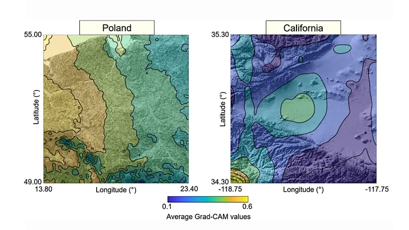
Tested in regions like Poland and California, the system didn't just enhance GNSS-derived humidity fields but also employed explainable AI, making its logic transparent. The marriage of GNSS with the Weather Research and Forecasting (WRF) model brought dazzling results: errors dropped by an astonishing 62% in Poland and 52% in California, even amidst challenging rainy conditions.
A Clearer Picture of Weather Dynamics!
Compared to traditional methods, the SRGAN approach produced sharper structures and finer gradients that aligned more closely with reference data. With explainable AI tools like Grad-CAM and SHAP, the model revealed its attention on crucial storm-sensitive areas, providing insights where it mattered most.
A New Era of Trust in AI Meteorology
Lead author Saeid Haji-Aghajany states, "High-resolution atmospheric data is the missing link in forecasting disruptive weather. Our method doesn’t just refine data—it clarifies AI’s decision-making, fostering trust in AI-enhanced meteorology. The hidden details of storms and humidity? Now at our fingertips!"
Implications for Communities at Risk
This breakthrough isn't just for academics—it's a vital tool for meteorologists! Enhanced humidity fields can significantly elevate storm prediction and early warning systems, allowing vulnerable communities to receive quicker, more reliable alerts against flash floods, hurricanes, or sudden downpours.
A Bright Future Ahead!
As this revolutionary method is integrated into global weather networks, it has the power to transform how we navigate the challenges of a rapidly changing climate. Get ready for a more resilient future against nature’s unpredictability!


 Brasil (PT)
 Canada (EN)
 Chile (ES)
 Česko (CS)
 대한민국 (KO)
 España (ES)
 France (FR)
 Hong Kong (EN)
 Italia (IT)
 日本 (JA)
 Magyarország (HU)
 Norge (NO)
 Polska (PL)
 Schweiz (DE)
 Singapore (EN)
 Sverige (SV)
 Suomi (FI)
 Türkiye (TR)
 الإمارات العربية المتحدة (AR)