NASA's High-Flying Labs: Uncovering Earth's Hidden Treasures from the Sky
2025-07-16
Author: Rajesh
Unlocking Earth’s Secrets from Above
While NASA is renowned for its explorations of the cosmos, its cutting-edge technology is also playing a pivotal role in discovering invaluable minerals right here on Earth. A groundbreaking initiative is underway that harnesses instruments originally crafted for space missions to map critical resources beneath our feet.
The GEMx Revolution
Led by the U.S. Geological Survey and NASA's Jet Propulsion Laboratory (JPL), the Geological Earth Mapping Experiment, known as GEMx, is making history as possibly the largest airborne spectroscopic survey in the United States. This innovative project stems from decades of NASA technology and aims to identify essential minerals across the American West.
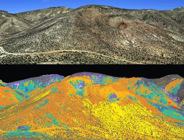
Cuprite, Nevada: A Surreal Testing Ground
Enter Cuprite, Nevada—a landscape that looks eerily reminiscent of Mars. With its dry, pallid hills and ancient water scars, it's the perfect testing ground for NASA's sensors. For over a century, this mineral-rich area has attracted prospectors, making it a prime location for scientists to refine technology that could analyze similar terrains across the solar system.
From Space to Earth: Mapping from 60,000 Feet
At a staggering 60,000 feet (18,200 meters), NASA’s aircraft equipped with advanced sensors are on a mission. These machines can detect the molecular composition of the rocks below, capturing light patterns that elude the human eye. In just a short span since 2023, the GEMx campaign has mapped over 190,000 square miles (492,000 square kilometers) of terrain—a swath nearly the size of Spain.
A Legacy of Collaboration
The cooperative spirit between NASA and the U.S. Geological Survey traces back to the Apollo era, when USGS geologists provided detailed lunar maps essential for safe astronaut landings. This partnership continues to flourish as they groom the next generation of explorers through NASA's Artemis program.
The Science Behind the Technology
At the core of GEMx is a powerful technology called imaging spectroscopy, which has been evolving since the 1980s. Each molecule has a distinct way of reflecting and absorbing light—like a fingerprint. The key instrument, AVIRIS-Classic, functions as a sophisticated imaging spectrometer, capturing over 200 different wavelengths, including infrared spectra.
The New Age of Mineral Discovery
AVIRIS has been operational for over three decades, but it's now joined by its cutting-edge successor, AVIRIS-5, which promises sharper imaging capabilities. Flying high aboard a specially equipped NASA ER-2 aircraft—akin to a high-altitude science laboratory—these instruments are set to revolutionize mineral mapping across the Western U.S. until fall 2025.
Mapping the Future.
Once the data from these high-altitude flights has been processed, the U.S. Geological Survey will unveil detailed mineral maps that could transform future mining endeavors and significantly lessen U.S. reliance on imported materials. As NASA scans the expansive skies, quietly collecting valuable data, the mission is clear: understand our existing resources better and strategize for a more self-sufficient future.


 Brasil (PT)
 Canada (EN)
 Chile (ES)
 Česko (CS)
 대한민국 (KO)
 España (ES)
 France (FR)
 Hong Kong (EN)
 Italia (IT)
 日本 (JA)
 Magyarország (HU)
 Norge (NO)
 Polska (PL)
 Schweiz (DE)
 Singapore (EN)
 Sverige (SV)
 Suomi (FI)
 Türkiye (TR)
 الإمارات العربية المتحدة (AR)