Mystery Solved: How a Gigantic Boulder Ended Up on a Cliff in Tonga
2025-05-28
Author: Mei
A Giant Puzzle Uncovered: The Maka Lahi Boulder
Deep within the breathtaking landscapes of Tonga lies a colossal boulder, sitting precariously on the edge of a cliff, revealing an extraordinary tale of nature's power. This massive rock, discovered in 2024 on the island of Tongatapu, has captivated researchers with its mysterious origins, believed to have been transported there by a colossal ancient tsunami.
Unraveling the Mystery: A Tsunami's Trail
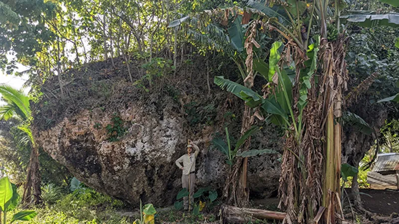
Measuring a staggering 45.9 x 39.3 x 22 feet and weighing over 1,300 tons, the boulder, named Maka Lahi (which translates to "big rock" in Tongan), is situated 656 feet inland and 128 feet above sea level. Initially spotted by local farmers while researchers were surveying the southern coastline for evidence of past tsunamis, its existence raised numerous questions about how such a massive structure ended up so far from the coast.
Lead researcher Martin Köhler from the University of Queensland expressed his astonishment, stating, "It’s located far inland outside of our fieldwork area and must have been carried by a very big tsunami. It was quite unbelievable to see this big piece of rock sitting there covered in and surrounded by vegetation."
A Study Reveals the Past: The Power of a Giant Wave
Published in the journal Marine Geology on April 21, a new study suggests that Maka Lahi was likely deposited at its current location during a massive tsunami that struck the island approximately 7,000 years ago. To understand the wave's sheer magnitude, researchers modeled the size of it necessary to carry such a behemoth of a rock, hypothesizing that it may have originally rested at the cliff's edge, only to be swept inland by a tsunami wave reaching heights of up to 164 feet—almost equivalent to Niagara Falls!
Tracing the Timeline: How Old is Maka Lahi?
Utilizing isotopic dating methods, the researchers concluded that the boulder was likely relocated to its current spot at least 6,891 years ago, a timeframe aligning perfectly with geological evidence of a significant tsunami event affecting New Zealand’s North Island—about 1,300 miles away. This stormy past raises the possibility of a simultaneous earthquake event causing additional geological upheaval.
Tonga's Tsunami Challenges: A Call for Preparedness
The Tongan islands, located in the South Pacific's notorious "Ring of Fire," are no strangers to seismic activity and tsunamis generated by tectonic friction and volcanic eruptions. This backdrop adds urgency to the need for disaster preparedness. Tonga experienced a tragic tsunami in 2022, caused by a volcanic eruption, resulting in loss of life and extensive damage.
As Dr. Annie Lau, a coastal geomorphologist at the University of Queensland, noted, "Understanding past extreme events is critical for hazard preparation and risk assessment now and in the future." The insights gained from Maka Lahi's journey across the landscape could be vital for enhancing tsunami risk evaluations in coastal regions globally.
Conclusion: Learning from Nature’s Fury
As scientists continue to delve into the secrets of the Maka Lahi boulder, they are not just piecing together a geological puzzle but also paving the way for future safety measures in a region that remains vulnerable to nature's wrath. This giant boulder is more than just a rock; it's a powerful reminder of how the earth shapes its own landscape.


 Brasil (PT)
 Canada (EN)
 Chile (ES)
 Česko (CS)
 대한민국 (KO)
 España (ES)
 France (FR)
 Hong Kong (EN)
 Italia (IT)
 日本 (JA)
 Magyarország (HU)
 Norge (NO)
 Polska (PL)
 Schweiz (DE)
 Singapore (EN)
 Sverige (SV)
 Suomi (FI)
 Türkiye (TR)
 الإمارات العربية المتحدة (AR)