L3Harris Revolutionizes Weather Monitoring with First GOES-19 Image Capture!
2024-09-19
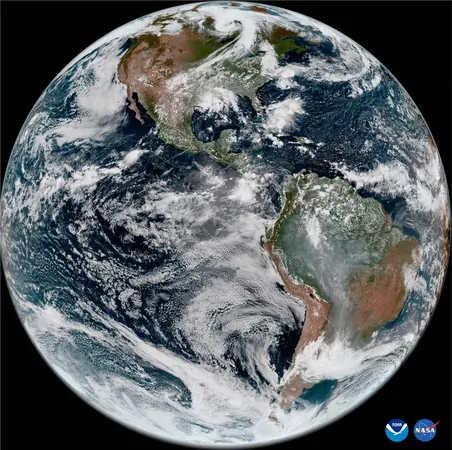
In an exciting breakthrough for meteorological science, the L3Harris Technologies Advanced Baseline Imager (ABI) aboard NOAA's latest weather satellite, GOES-19, has successfully captured its inaugural image! This significant achievement follows the satellite's launch in late June, marking a pivotal step toward its full operational capabilities. The stunning GeoColor image was taken on August 30, 2024, showcasing the satellite's comprehensive view of the Earth.
The ABI is not just any imaging device; it is the cornerstone technology for NOAA's Geostationary Operational Environmental Satellite-19 (GOES-19), which stands as the fourth and final addition to the highly advanced GOES-R Series. Known for its impressive high-resolution imaging capabilities, the ABI is designed to quickly and effectively detect and monitor severe weather phenomena, including thunderstorms, wildfires, and hurricanes—essential tools for safeguarding lives and properties.
Ed Zoiss, President of Space and Airborne Systems at L3Harris, emphasized the significance of this milestone: “Since its first launch in 2016, our ABI has been providing NOAA meteorologists with world-class imaging capabilities, enabling the timely warning of hazardous weather across the entire Western Hemisphere. As we celebrate this achievement, L3Harris is dedicated to supporting ABI on-orbit operations and future NOAA initiatives aimed at delivering critical, real-time weather data for decades to come.”
GOES-19 is part of an ambitious global satellite constellation that includes seven ABI-class instruments—four for NOAA, two dedicated to Japan, and one for South Korea. This international collaboration enhances global weather understanding and disaster response capabilities. Looking ahead, L3Harris is also working on the Geostationary Extended Observations (GeoXO) Imager (GXI), NOAA's next-generation geostationary imager set to launch in 2032, which will facilitate unprecedented insights into environmental threats as it continues to operate into the 2050s.
Stay tuned as L3Harris and NOAA propel weather observation technology into the future, ensuring communities have access to vital information that can help mitigate the impacts of natural disasters. This is just the beginning of a thrilling era in weather monitoring!


 Brasil (PT)
 Canada (EN)
 Chile (ES)
 España (ES)
 France (FR)
 Hong Kong (EN)
 Italia (IT)
 日本 (JA)
 Magyarország (HU)
 Norge (NO)
 Polska (PL)
 Schweiz (DE)
 Singapore (EN)
 Sverige (SV)
 Suomi (FI)
 Türkiye (TR)