Enigmatic Dust Storms Blanket China’s Tarim Basin
2025-04-13
Author: Sarah
Witness the Dusty Veil of the Tarim Basin
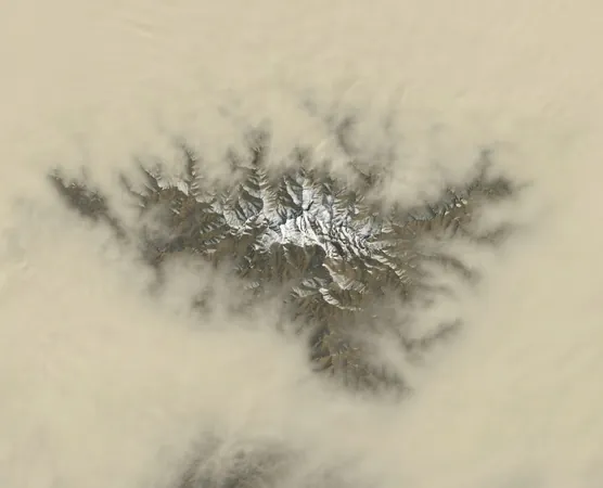
A mesmerizing image from NASA Earth Observatory reveals a stunning blanket of dust enveloping the Tarim Basin, an expansive and arid region in northwestern China. Amidst this dusty haze, the majestic peaks of the Tekilik Shan mountains peek through, reminding us of the geological wonders hidden beneath.
Tekilik Shan: The Veiled Giants
Though lesser-known than their neighboring ranges, the Tekilik Shan mountains play a crucial role in molding the basin’s weather patterns and landscape. These snow-capped giants can reach elevations of over 13,000 feet, contributing to the extraordinary topographical variations of this region.
Springtime Dust Storm Spectacle
As spring arrives, the Tarim Basin gears up for its peak dust storm season, particularly in the southern areas. According to NASA, the seasonal shift in wind patterns unleashes powerful gales from the northwest, stirring up the already parched terrain. With minimal vegetation and dry soils, the landscape warms rapidly each morning, leading to strong convective currents that lift dust high into the atmosphere.
Nature’s Artistry: Fingerlike Dust Formations
Satellite imagery unveils intricate, fingerlike dust formations that mimic the valley landscapes below. This phenomenon is orchestrated by narrow valleys that channel airborne dust, creating stunning visual patterns. Atmospheric scientist Ralph Kahn indicates this dust may be 'self-lofting,' where sunlight heats the stirred-up dust, forming convection pockets that propel it even higher into the sky. Observations from Japan’s Himawari-9 satellite illustrate this gradual ascent of dust as it eventually shrouds the mountains by afternoon.
Declining Dust: A Long-Term Trend
Interestingly, long-term satellite data from MODIS shows a 1.5 percent yearly decline in atmospheric dust levels in the Tarim Basin since the early 2000s. NASA researcher Hongbin Yu attributes this trend to changes in spring conditions—like wind speeds and soil moisture—rather than seasonal alterations.
The Dry Heart of the Tarim Basin
The Taklamakan Desert, one of the driest regions on our planet, lies at the core of the Tarim Basin. Surrounded by towering mountain ranges, this desert receives a mere 10 millimeters (0.4 inches) of rainfall annually. Dust storms originating here pose significant health risks to nearby populations, carrying harmful particles and pathogens that can compromise respiratory health.
Geological Wonders and Historical Significance
The Tarim Basin, one of the largest endorheic basins globally, is rich in natural resources, particularly oil and gas. Historically, it served as a crucial section of the ancient Silk Road, with oases like Kashgar and Khotan acting as essential trading hubs for centuries. However, the harsh climate and remote location pose challenges for infrastructure development and habitation.
A Stunning Satellite Snapshot
This awe-inspiring image, captured on March 27, 2025, by the Operational Land Imager on Landsat 8, offers a breathtaking glimpse into the fascinating yet unforgiving landscape of the Tarim Basin.


 Brasil (PT)
 Canada (EN)
 Chile (ES)
 Česko (CS)
 대한민국 (KO)
 España (ES)
 France (FR)
 Hong Kong (EN)
 Italia (IT)
 日本 (JA)
 Magyarország (HU)
 Norge (NO)
 Polska (PL)
 Schweiz (DE)
 Singapore (EN)
 Sverige (SV)
 Suomi (FI)
 Türkiye (TR)
 الإمارات العربية المتحدة (AR)