Earth-Shaking Discoveries: Tsunamis Captured for the First Time
2025-07-24
Author: Wei Ling
A Mysterious Signal Shakes the Earth
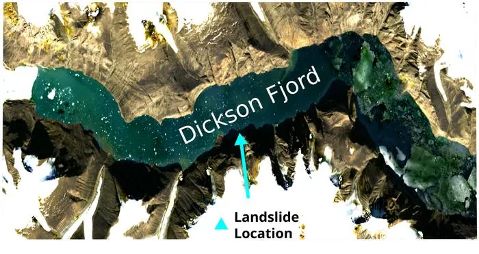
In September 2023, seismic sensors worldwide detected a puzzling phenomenon: the Earth trembled every 90 seconds. Initial confusion reigned, but a similar occurrence in October led researchers to investigate. The cause? It was theorized that standing waves, known as seiches, formed after massive landslides triggered colossal tsunamis in a narrow waterway off Greenland.
Oxford Engineers Unveil Groundbreaking Images
Engineers at the University of Oxford have confirmed this theory by utilizing satellite altimetry data from the Surface Water Ocean Topography (SWOT) mission. This cutting-edge technology allowed them to create the first-ever images of these seiches, demonstrating their origin from massive landslide-induced tsunamis in Dickson Fjord. With climate change exacerbating such events, ongoing investments in advanced satellite missions are deemed crucial for monitoring our planet.
An Unprecedented Look into a Hidden World
Unlike standard altimeters, SWOT offers detailed two-dimensional measurements of sea surface height around the globe, even in remote areas like fjords and rivers. Thomas Monahan, co-leader of the team, illustrated the mission's significance: "We captured unprecedented views of Dickson Fjord during the seiche events, allowing us to assess how the water surface tilted during these waves."
The Shocking Scale of Seiches
The altimeter maps revealed dramatic height differences—cross-channel slopes with variations up to two meters, indicating water movement in both directions. However, proving these observations were genuine seiches turned out to be the real challenge. Monahan humorously likened their task to a game of Cluedo, systematically ruling out alternatives.
Tsunami Forces that Shook the Globe
While nobody was present in Dickson Fjord during these seiche events, the scientists estimated the tumultuous scenes as truly terrifying. Thanks to sophisticated machine-learning analyses, they determined the initial height of the September seiche at an astonishing 7.9 meters, while the October seiche reached 3.9 meters.
"The force of all that water sloshing back and forth in the fjord was tremendous," Monahan noted, comparing it to the combined might of 14 Saturn V rockets launching simultaneously—an impact strong enough to rattle the Earth for days.
Climate Change's Role and Future Risks
The geometry of the fjord played a crucial role in amplifying these powerful seiches, with sharp curves trapping waves to resonate for extended periods. As these seismic waves traveled globally, they highlighted the potential dangers posed by climate change-induced landslides. Monahan indicated that the thinning of glaciers could lead to more frequent landslides, raising the risk of such devastating tsunamis.
Looking Ahead: Understanding Seiche Dissipation
The researchers aspire to further explore how these seiches dissipate after their formation: "While we can simulate the stabilization of megatsunamis into seiches, their decay remains poorly understood," Monahan explained. Future studies utilizing SWOT satellite observations may reveal critical insights into these complex processes.


 Brasil (PT)
 Canada (EN)
 Chile (ES)
 Česko (CS)
 대한민국 (KO)
 España (ES)
 France (FR)
 Hong Kong (EN)
 Italia (IT)
 日本 (JA)
 Magyarország (HU)
 Norge (NO)
 Polska (PL)
 Schweiz (DE)
 Singapore (EN)
 Sverige (SV)
 Suomi (FI)
 Türkiye (TR)
 الإمارات العربية المتحدة (AR)