Revolutionary Satellite Technology to Combat Wildfires Before They Escalate!
2024-09-16
Revolutionary Satellite Technology to Combat Wildfires Before They Escalate!
In an ambitious attempt to curb the devastating impact of wildfires, a groundbreaking initiative called FireSat, supported by Google, is set to harness satellite technology to detect small fires long before they spiral out of control. This innovative project merges the scientific expertise of a newly formed nonprofit coalition, the Earth Fire Alliance, with the cutting-edge satellite capabilities of Muon Space.
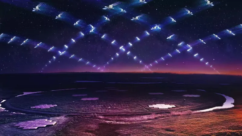
The Earth Fire Alliance, aided by funding from Google.org, aims to deploy a constellation of satellites into low Earth orbit with the express purpose of monitoring wildfire activity. Christopher Van Arsdale, the lead researcher at Google Research’s Climate and Energy group, highlighted, “There is a significant gap between the data we have available today and what we could have with better satellite coverage.” This underscores the urgent need for advanced technology in an era marked by increasing wildfire risk due to climate change.
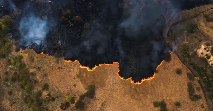
As rising temperatures and prolonged droughts contribute to more ferocious wildfires, it has become critical for scientists and emergency responders to find more efficient tools to protect communities. Existing satellites can help track large wildfires, but the hope is that FireSat will deliver unparalleled data accuracy and consistency, allowing for the early detection of flames far more effectively than current technology and ground-based methods.
Currently, wildfires are often first detected by human eyes or aerial surveillance. Existing satellite systems can only observe fires a handful of times throughout the day and typically require flames to grow to a certain size before they can be detected. FireSat aims to bridge that gap, promising to monitor wildfire activities every 20 minutes from over 50 dedicated satellites, and capable of detecting fires as small as 5 x 5 meters (about the size of a typical classroom). This is a dramatic enhancement from previous satellites, which needed to identify blazes of at least two acres (comparable to two football fields).
To achieve this groundbreaking capability, the project has developed specialized sensors and cutting-edge algorithms powered by artificial intelligence. These technologies will allow FireSat to continuously analyze snapshots of specific areas over time, quickly identifying any emerging fire threats and contributing to a global database of fire spread for academic research.
The first FireSat satellite is scheduled for launch in early 2025, with additional units planned for 2026. Although the Earth Fire Alliance was publicly launched this year, the development of FireSat’s technology has been underway for the past five years.
Kate Dargan Marquis, a former California state fire marshal and current senior adviser at the Gordon and Betty Moore Foundation, emphasized the transformative potential of FireSat for those fighting fires on the frontlines. "As a former firefighter, I can personally attest to the difference that this will make for firefighters in the field today. It is a game changer, especially as wildfires are becoming more extreme, more frequent and more dangerous for everyone. Information like this will make a life-saving difference.”
Could this high-tech wildfire detection system be the key to saving lives and protecting our natural landscapes from irreversible damage? Only time will tell, but the implications of FireSat's success could change the fate of wildfire management across the globe.

 Brasil (PT)
 Canada (EN)
 Chile (ES)
 España (ES)
 France (FR)
 Hong Kong (EN)
 Italia (IT)
 日本 (JA)
 Magyarország (HU)
 Norge (NO)
 Polska (PL)
 Schweiz (DE)
 Singapore (EN)
 Sverige (SV)
 Suomi (FI)
 Türkiye (TR)