Hurricane John Strikes Mexico: Urgent Caution As Flooding and Landslides Loom
2024-09-24
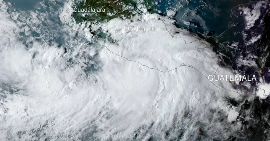
Hurricane John Makes Landfall
Hurricane John made a dramatic landfall along the western coast of Mexico late Monday, intensifying rapidly to a menacing Category 3 storm. This powerful hurricane has brought with it heavy rains, significantly raising concerns of flooding and potential landslides across the Pacific coast.
Impact on Coastal Communities
The effects of John were felt prominently from Oaxaca's central coast all the way to Acapulco, a popular resort city in Guerrero that still bears the scars of last October’s Hurricane Otis, which unexpectedly escalated to Category 5 intensity. 'It’s something we have been through before, and all that remains is to wait for the storm to pass,' said local resident Mr. Ponce, 47, reflecting the palpable anxiety in the region amidst the storm’s approach.
Response Measures
As the storm unleashed its relentless rains, early reports highlighted incidents of landslides that disrupted traffic on newly constructed highways. The national electricity commission swiftly reacted by deploying nearly 1,400 electricians armed with cranes and emergency power plants to mitigate potential outages. Civil protection authorities rapidly coordinated the opening of shelters across approximately 50 municipalities in Oaxaca, demonstrating a precautionary readiness in the face of uncertainty. 'Although John’s trajectory has changed, it remains unstable, and we must continue monitoring the phenomenon,' stated Esteban Vásquez Hernández, the regional civil protection coordinator.
Climate Change and Hurricanes
Recent scientific studies indicate that the rapid intensification witnessed with storms like John is increasingly common, particularly in the Atlantic. This shift is attributed largely to climate change, driven by emissions from fossil fuels. Earlier this year, a record-breaking Hurricane Beryl exemplified this trend, transforming into Category 4 and then Category 5 status at unprecedented speed.
Warnings and Precautions
Experts are now warning of the potential impact of John’s hurricane-force winds and accompanying storm surge, which could trigger severe flooding. Globally rising temperatures are linking to intensified rainfall from hurricanes, making conditions even more treacherous. Carrie Stevenson, a hurricane preparedness researcher at the University of Florida, expressed grave concerns regarding the rainfall forecast. 'It’s going to be a huge rainmaker,' she warned. 'Flash flooding could be the most dangerous part of this storm.' Adding to the complexity, forecasters suggest that should John maintain its strength, it may traverse Mexico and re-emerge in the Gulf of Mexico, where another storm currently dubbed Potential Tropical Cyclone Nine is on track to move north this week.
Public Advisory
Residents along the coast are urged to remain vigilant and heed official warnings as Hurricane John continues to unfold, highlighting not only the immediate dangers but also the broader implications of our changing climate.

 Brasil (PT)
 Canada (EN)
 Chile (ES)
 España (ES)
 France (FR)
 Hong Kong (EN)
 Italia (IT)
 日本 (JA)
 Magyarország (HU)
 Norge (NO)
 Polska (PL)
 Schweiz (DE)
 Singapore (EN)
 Sverige (SV)
 Suomi (FI)
 Türkiye (TR)