Unveiling the Secrets of Yilan Crater: A Violent Legacy of Meteorite Impact
2025-05-18
Author: Michael
Asteroid Impacts: Nature's Sculptors
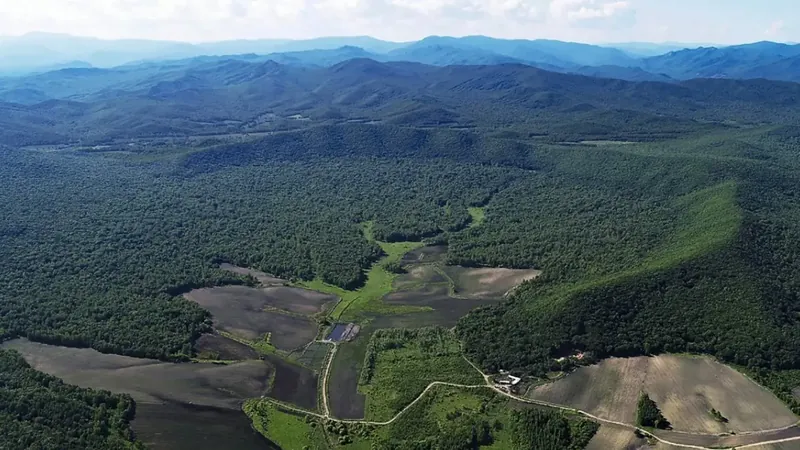
For billions of years, catastrophic asteroid impacts have sculpted Earth's surface, leaving a trail of craters that serve as valuable geological chronicles of high-energy events. Among these markers, the Yilan Crater in northeastern China stands out—a striking, well-preserved remnant of a meteorite collision that occurred during the Late Pleistocene, encompassing a dramatic diameter of 1.85 km (1.14 miles).
A Hidden History Beneath the Surface
Concealed under layers of lake sediments, Yilan Crater harbors distinct shock signatures—fractured granite, molten rock features, and high-pressure minerals that reveal the traces of hypervelocity impact. Radiocarbon dating of charcoal found within the sediment fill indicates that this explosive event took place roughly 49,000 years ago, marking Yilan as the second confirmed impact site in China, trailing only the Xiuyan Crater.
Unlocking the Crater's Mysteries with Seismic Technology
Geophysical exploration of the Yilan Crater’s subsurface remained largely uncharted until recently. In 2023, a team of researchers deployed an extensive array of seismic sensors throughout the site. By capturing ground vibrations and seismic waves originating from distant earthquakes, they successfully mapped the crater's internal structure, allowing them to reconstruct the impact event with unprecedented accuracy.
Inside the Bowl: Seismic Mapping Reveals the Crater's Structure
To gain insight into what lies beneath the surface, the team established a grid of seismic sensors across the crater. Analyzing natural ground vibrations through techniques like ambient noise tomography uncovered a distinct bowl-shaped formation beneath the site. This structure exhibited slower seismic wave speeds, consistent with a thick veneer of loose material and fractured rock, which aligns with expectations from a meteorite impact.
Measuring the Impact's Power: A Geological Investigation
Utilizing seismic data from their extensive network, the researchers calculated the sediment layer's thickness within the crater. At the center, they discovered a notably low natural vibration frequency of 0.579 Hz, which pointed to sediment depths between 125 to 165 meters (410 to 540 feet). This finding corroborated earlier drilling depths of 110 meters (360 feet) and aligned with variations in seismic wave speeds observed during tests.
The Force Behind Yilan: What Kind of Object Caused This?
To delve deeper into the nature of the object that formed the Yilan Crater, researchers simulated various impact scenarios, adjusting parameters such as object size, speed, and entry angle. Despite numerous combinations yielding comparable crater dimensions, the impact energy remained largely consistent, typically ranging from 0.75 to 2 × 10¹⁷ joules. The most plausible scenario involved a mid-sized rocky object impacting Earth at a 45-degree angle, delivering around 1 × 10¹⁷ joules of energy—a force comparable to a magnitude 5.5 earthquake.
Yilan's Impact: A Cataclysm of Historical Proportions
Though the Yilan impact pales in comparison to the infamous Chicxulub event that heralded the demise of the dinosaurs, it unleashed significantly more energy than the Meteor Crater in Arizona. The explosion would have generated serious environmental changes in the surrounding landscape. The timing of the crater's formation—around 49,300 years ago—overlaps with the presence of megafauna, such as mammoths, in the region. Fossils dated to between 48,000 and 42,000 years ago raise intriguing questions about potential links between this impact and local extinction or migration events.
The Future of Impact Studies: Seismic Methods in Action
Research like this is crucial in addressing the knowledge gaps surrounding smaller impact craters, which often go unnoticed due to erosion or burial. The Yilan Crater's well-preserved state makes it a prime site for comparative studies of similar features on the Moon, Mars, and beyond. Furthermore, this investigation demonstrates the efficacy of passive seismic methods in studying impact sites, particularly in regions where active surveys are challenging. Even low-frequency ground noise can unveil significant details about subsurface geology, paving the way for future explorations.


 Brasil (PT)
 Canada (EN)
 Chile (ES)
 Česko (CS)
 대한민국 (KO)
 España (ES)
 France (FR)
 Hong Kong (EN)
 Italia (IT)
 日本 (JA)
 Magyarország (HU)
 Norge (NO)
 Polska (PL)
 Schweiz (DE)
 Singapore (EN)
 Sverige (SV)
 Suomi (FI)
 Türkiye (TR)
 الإمارات العربية المتحدة (AR)