Unprecedented Snowfall Hits Eastern Canada as Storms Defy Norms
2025-01-07
Author: Liam
Unprecedented Snowfall Hits Eastern Canada as Storms Defy Norms
Eastern Canada is bracing for a wave of snow that challenges conventional weather patterns this week, with some regions in Quebec and the Atlantic provinces expected to receive staggering amounts of snowfall—up to 40 centimeters in some areas.
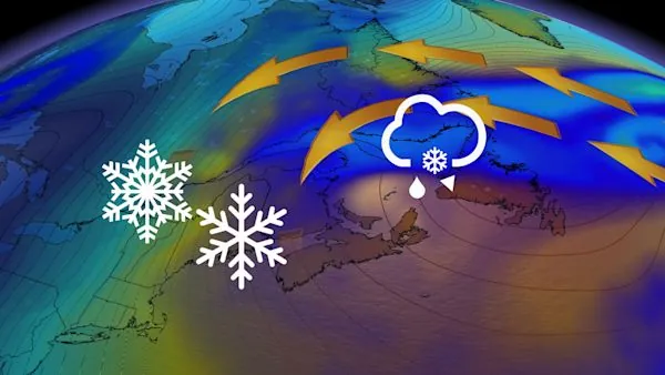
Typically, storms across Canada move from west to east, but this week, a peculiar reverse track has developed, causing a powerful storm to linger over Atlantic Canada instead of veering out to sea. This unusual weather phenomenon is attributed to a strong blocking pattern over the North Atlantic, resulting in an extended period of snow.
As Canada grapples with fluctuating temperatures, the Great Lakes region is experiencing its coldest spell of the season, while Quebec and the East Coast are set to face extreme winter weather.
What's in Store for Quebec and Atlantic Canada?
The storm system, an upper-level low, is expected to rotate over Eastern Canada for several days, leading to frequent snowfall across Quebec and the Atlantic provinces. In a curious twist, the snow will predominantly move from east to west—something rarely seen in the region's meteorological records.
For those in Quebec, the Gaspé Peninsula is bracing for the heaviest snowfall, with forecasts suggesting accumulated totals might reach up to 30 centimeters in its higher elevations. However, in Montreal, snow flurries may lead to particularly slippery conditions, reminding commuters to exercise caution and plan for delays in travel.
Travel impacts will resonate throughout the region, as snowfall and reduced visibility—plummeting to near-zero standards in heavy, blowing snow—become common threats. Travelers are advised to keep a close eye on weather updates and adjust their journeys accordingly.
Further east, noteworthy snow bands are predicted to affect Nova Scotia, especially Cape Breton, where up to 40 centimeters of snow may accumulate. Prince Edward Island could see between 5 to 15 centimeters, hinting at significant disruptions to travel plans.
In northeastern Newfoundland and Labrador, heavy precipitation is on the horizon, with a mix of rain and snow heralding a tumultuous weather week. Despite the expected snowfall, a warm front sweeping in from the Atlantic may keep temperatures close to the freezing mark, making certain days milder than even Nashville, Tennessee.
As this curious winter situation unfolds, residents are encouraged to stay informed with the latest updates and forecasts to navigate this challenging weather week safely.
Stay tuned for ongoing coverage as meteorologists continue to track this anomaly in Eastern Canada's weather patterns.


 Brasil (PT)
 Canada (EN)
 Chile (ES)
 Česko (CS)
 대한민국 (KO)
 España (ES)
 France (FR)
 Hong Kong (EN)
 Italia (IT)
 日本 (JA)
 Magyarország (HU)
 Norge (NO)
 Polska (PL)
 Schweiz (DE)
 Singapore (EN)
 Sverige (SV)
 Suomi (FI)
 Türkiye (TR)
 الإمارات العربية المتحدة (AR)