Unlocking the Secrets of the San Andreas Fault: Could the ‘Big One’ Be on the Horizon?
2025-06-22
Author: William
The Hidden Dangers of the San Andreas Fault
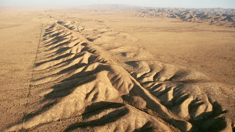
Nestled beneath the sunny state of California lies one of the most notorious geological features: the San Andreas Fault. This isn't just any fault; it's a right-lateral strike-slip fault, meaning that if you were to stand on one side facing the Pacific Ocean, the other side would be creeping sideways to the right. This monstrous fracture in the Earth’s crust is responsible for the seismic activity that could potentially unleash the dreaded 'Big One'.
Segments of a Sleeping Giant
The San Andreas Fault stretches an astonishing 746 miles (1,200 km) and is split into three principal segments, each with its own characteristics and risks. The southern segment begins near Bombay Beach, California, and runs up to Parkfield, posing a significant threat to the bustling metropolis of Los Angeles. Given the population density of this area, a quake here would have catastrophic consequences.
In stark contrast is the middle segment, dubbed the 'creeping section.' Extending from Parkfield to Hollister, this area moves slowly, causing little to no shaking, but scientists suspect it has seen its own share of quakes over the millennia, even if they haven’t been recorded recently.
At the northern end, the fault meets the enigmatic 'triple junction' near Mendocino, where the North American, Pacific, and Gorda plates converge. Here, the boundary shifts into a different geological phenomenon called a subduction zone, where the Pacific Plate dives beneath the North American Plate.
More Than Just a Crack in the Ground
The San Andreas is not just an isolated crack; it's part of a vast network of faults known as the San Andreas Fault Zone. Among these, the Hayward Fault in the East Bay is notorious for its own history of devastating earthquakes. In 1868, a 6.8 magnitude quake struck, claiming 30 lives. If a similar catastrophe were to occur today, the bustling Bay Area could face dire consequences.
A Historical Perspective on Earthquake Risks
The geology of the region is a result of intense tectonic activity that began about 30 million years ago when oceanic and continental plates collided. This collision formed the basis for the San Andreas Fault, drastically altering the geological landscape of Western North America. With the possibility of producing earthquakes, scientists place significant importance on monitoring its activity.
The Unpredictable Nature of Earthquakes
Geologists estimate that the southern San Andreas could unleash a quake as magnitudinous as 8.3, dwarfing past disasters such as the 7.9 magnitude quakes of 1857 and 1906. The Loma Prieta earthquake of 1989, measuring 6.9, caused considerable damage and loss of life, underscoring the fault’s destructive potential. A 7.8 quake today could result in 1,800 fatalities and $200 billion in damages.
Preparing for the Inevitable?
Despite advanced technology, predicting the exact timing of earthquakes remains elusive. However, history provides clues about future risks. Some segments of the southern San Andreas seem to experience significant quakes every century or so, while others can remain quiet for up to 300 years.
As a point of concern, the Fort Tejon area, situated just north of Los Angeles, is overdue for a large quake, having last experienced significant seismic activity in 1857.
A Grim Forecast for California
The U.S. Geological Survey has crunched the numbers, revealing a staggering 72% chance of a 6.7 magnitude earthquake in the San Francisco Bay region by 2043, and a 60% likelihood for a similar quake in Los Angeles. As California continues to expand, the looming shadow of the San Andreas Fault serves as a constant reminder of nature's unpredictable power.
Stay alert, California—Earth’s fury could strike at any moment!


 Brasil (PT)
 Canada (EN)
 Chile (ES)
 Česko (CS)
 대한민국 (KO)
 España (ES)
 France (FR)
 Hong Kong (EN)
 Italia (IT)
 日本 (JA)
 Magyarország (HU)
 Norge (NO)
 Polska (PL)
 Schweiz (DE)
 Singapore (EN)
 Sverige (SV)
 Suomi (FI)
 Türkiye (TR)
 الإمارات العربية المتحدة (AR)