Unlocking the Secrets of Aufeis: Groundbreaking Research in Trans-Himalaya
2024-12-09
Author: Emma
Introduction
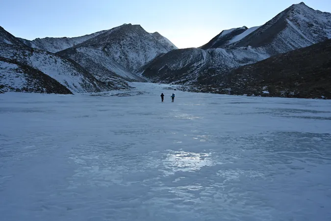
A pioneering team of geographers from the South Asia Institute at Heidelberg University has unveiled intriguing insights into the largely unexplored phenomenon of aufeis fields in the Trans-Himalayan region of Ladakh, India. This study, spearheaded by the esteemed Prof. Dr. Marcus Nüsser, harnesses advanced technology to examine the thickness and volume of these unique ice formations, which play a vital role in local water supply dynamics.
Research Approach
Using high-resolution remote sensing data and terrestrial images, the team meticulously compared the volume of naturally occurring ice against that of artificially created ice reservoirs. Their approach—analyzing the discrepancies between winter and summer terrain models—reveals crucial information about the seasonal ice deposits and the often hidden hydrogeological conditions beneath.
What is Aufeis?
For those unfamiliar, aufeis is a fascinating hydrological phenomenon found primarily in cold-arid and permafrost regions. It develops during winter through a process of repeated freezing of spring water or small stream flow. These impressive ice layers, which can reach meters in thickness, are not just spectacular sights; they are essential for sustaining local ecosystems and human populations as they contribute significantly to water supplies during the spring thaw.
Key Findings
The research team discovered that while aufeis is prevalent throughout Ladakh and areas of the Tibetan Plateau—previous studies had already established this—it can occasionally be amplified by artificial ice reservoirs. To dive deeper into the nature of these seasonal ice accumulations, Prof. Nüsser's team conducted extensive investigations on two natural aufeis fields and two ice reservoirs during field studies in the fall of 2022 and spring of 2023.
The researchers took thousands of photographs of the sites and integrated these images with satellite data from the Pléiades satellite at the same time as their local evaluations. Their findings were striking: they estimated a total aufeis volume of up to a staggering 302,000 cubic meters, revealing that the natural aufeis fields were not only larger in area but often thicker—some even exceeding three meters at isolated points.
Implications for Groundwater Dynamics
These revelations lead to a groundbreaking understanding of groundwater dynamics in the region. According to Dr. Dagmar Brombierstädul, the annual overflow of groundwater at consistent sites during winter indicates that the formation of these aufeis fields can provide valuable insights into the hydrogeological characteristics of near-surface aquifers.
Conclusion and Future Directions
"Our research underscores the extensive distribution and significant water retention capabilities of aufeis fields," Prof. Nüsser remarks. "Yet, this crucial aspect has not yet been integrated into hydrological models." What's more, the high-resolution satellite imagery utilized in this research has proven indispensable for analyzing remote or otherwise inaccessible locations. Dr. Nüsser emphasizes, "These images empower us to draw deeper conclusions about the origin and structure of aufeis fields, enhancing our understanding of this remarkable phenomenon while allowing us to assess the potential impacts of climate change."
As climate change continues to reshape environmental patterns globally, this research could provide pivotal information for developing effective strategies for water resource management in regions that rely on these seasonal ice deposits. Stay tuned for more groundbreaking findings that might just alter our understanding of hydrology and climate resilience in some of the Earth's most remote regions!


 Brasil (PT)
 Canada (EN)
 Chile (ES)
 Česko (CS)
 대한민국 (KO)
 España (ES)
 France (FR)
 Hong Kong (EN)
 Italia (IT)
 日本 (JA)
 Magyarország (HU)
 Norge (NO)
 Polska (PL)
 Schweiz (DE)
 Singapore (EN)
 Sverige (SV)
 Suomi (FI)
 Türkiye (TR)
 الإمارات العربية المتحدة (AR)