Uncovering Auckland’s Urban Secrets: The Hidden Faults Beneath the Surface
2025-09-23
Author: Emma
A Geologist’s Journey into Auckland's Landscape
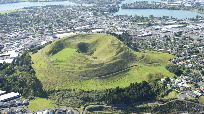
For years, Jill Kenny, a retired geologist and geomorphologist, has pondered the intriguing topography of Tāmaki Makaurau Auckland, New Zealand. Nestled on a volcanic isthmus, this bustling urban hub raised a question: What lies beneath its concrete facade? Despite being the country’s largest city, Auckland's hidden geological mysteries beckoned to be unveiled.
The Aha Moment: Unearthing Hidden Fault Lines
In 2004, after years of contemplation, Kenny's epiphany struck: the city’s distinct flat, eroded surfaces might be the result of offset faults. Unlike regions with frequent seismic activity, Auckland’s geological clues were obscured beneath layers of lava and ash, posing a challenge for scientists.
A Passion-Driven Research Adventure
Determined to unearth the truth, Kenny dove into thousands of borehole logs collected over the years. These logs housed vital data from geotechnical investigations that unveiled layers of ancient sedimentary rock dating back to the Miocene epoch. What she discovered was staggering—previously misidentified fault lines that dramatically altered the city’s geology.
Collaborative Insights: A Geospatial Breakthrough
In a groundbreaking study, Kenny collaborated with volcanologist Jan Lindsay and fellow researchers to analyze data from 8,200 boreholes paired with innovative remote sensing techniques. Their findings? A refined model of Auckland’s faulting, highlighting 10 likely and 25 potential faults, while discarding long-held misconceptions.
Seismic Risks in Urban Spaces
Cities are challenging landscapes for fault detection. With construction and urban life obscuring evidence, discovering active faults poses a significant challenge. "You can’t just dig up someone’s yard to investigate potential threats," remarked Nicolas Harrichausen, a crustal deformation expert.
The New Database: A Resource for the Future
Harrichausen pointed out that despite challenges, Auckland's new borehole database opens doors for further research into urban geomorphology. However, caution is warranted—fault activity is often categorized over vast timescales, making it difficult to ascertain immediate seismic risks.
Mapping a Volcano’s Power: Faults and Magma Interaction
Interestingly, the team’s fault mapping brought forth new questions regarding volcanic activity. The data indicated that while Auckland's volcanoes frequently erupted near faults, it remains unclear whether magma prefers to travel along or between these geological structures. As Lindsay noted, understanding the dynamics between faults and volcanoes is critical for assessing potential risks.
A Call to Action for Future Research
As the quest to comprehend Auckland's subterranean landscape continues, these revolutionary insights encourage further exploration into the region's seismic behavior. "Understanding our faults is pivotal for gauging seismic risks in the city," Lindsay urged, emphasizing the importance of mapping these geological wonders.
In conclusion, whether or not the faults identified are active, the research paves the way for a deeper understanding of Auckland's geological history and its potential threats, ensuring that the urban populace remains informed and prepared.


 Brasil (PT)
 Canada (EN)
 Chile (ES)
 Česko (CS)
 대한민국 (KO)
 España (ES)
 France (FR)
 Hong Kong (EN)
 Italia (IT)
 日本 (JA)
 Magyarország (HU)
 Norge (NO)
 Polska (PL)
 Schweiz (DE)
 Singapore (EN)
 Sverige (SV)
 Suomi (FI)
 Türkiye (TR)
 الإمارات العربية المتحدة (AR)