Revolutionizing Urban Growth Mapping: The Power of Deep Learning
2025-06-17
Author: William
Unlocking the Secrets of Urban Expansion
In a groundbreaking global study, researchers are tackling the intricate challenge of mapping urban expansion to build sustainable cities. With urban areas rapidly evolving, it's crucial to accurately capture their growth. This research specifically evaluates various machine learning and deep learning algorithms that extract urban footprints (UF) from high-resolution satellite imagery.
The Evolving Urban Landscape
As cities become more densely populated and complex, traditional land-use monitoring tools are falling short. The concept of the urban footprint has transformed; it now encompasses not only towering skyscrapers but also essential green spaces that enhance city livability and environmental quality. However, current extraction techniques struggle with obstacles like shadowing caused by high-rises and the confusion between different types of urban and natural environments.
Evaluating Urban Footprint Algorithms Across Cities
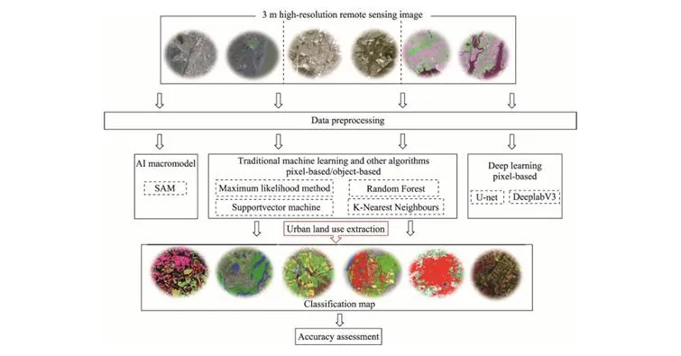
Published in March 2025 in the Journal of Geographical Sciences, this study from the University of Aberdeen tested several leading urban footprint extraction algorithms using high-resolution imagery from PlanetScope. The study spanned eight diverse cities globally, from compact historical centers to sprawling informal settlements.
Researchers compared pixel-based and object-based classification methods against advanced deep learning strategies, including the innovative Segment Anything Model (SAM). Their goal? To benchmark the trade-offs regarding precision, scalability, and operational efficiency for different urban contexts.
Unveiling Algorithm Performance
The results painted a complex picture of algorithm performance influenced by the city's unique characteristics. While traditional pixel-based methods like K-means and Support Vector Machine (SVM) excelled in areas with clear boundaries, they struggled in dense, high-rise environments. Object-based methods showed improved segmentation but relied heavily on the choice of classifier.
On the cutting edge, deep learning models like U-Net and DeeplabV3 demonstrated impressive accuracy—over 90% in many cases. U-Net was particularly adept at detailing fine urban aspects, while DeeplabV3 excelled in processing larger, noisier city landscapes. Yet, these models required high computational resources and substantial training time.
Conversely, the SAM model emerged as an accessible alternative that could deliver accuracy similar to deep learning methods in moderately complex settings but faltered in fragmented urban areas. These findings stress the need for choosing the right algorithm tailored to specific urban challenges.
Insights for Urban Planners and Policymakers
Lead author Baoling Gui emphasized the importance of adapting methods to the unique characteristics of each city, stating, "No single model fits all. Algorithm performance is influenced by city layout and the density and incorporation of green spaces." Understanding these trade-offs is essential for crafting effective urban mapping strategies.
Beyond academia, the implications of this research resonate with city planners and policymakers. Equipped with these insights, they can enhance monitoring systems for urban growth, climate adaptation, and sustainability, making accurate urban footprint mapping a vital tool for the future.
The Future of Urban Mapping: A Hybrid Approach?
The potential synergy between object-based methods and deep learning could pave the way for next-generation hybrid models that marry high performance with practical flexibility. As urban areas continue to evolve, such innovations will be crucial in navigating sustainability challenges around the globe.


 Brasil (PT)
 Canada (EN)
 Chile (ES)
 Česko (CS)
 대한민국 (KO)
 España (ES)
 France (FR)
 Hong Kong (EN)
 Italia (IT)
 日本 (JA)
 Magyarország (HU)
 Norge (NO)
 Polska (PL)
 Schweiz (DE)
 Singapore (EN)
 Sverige (SV)
 Suomi (FI)
 Türkiye (TR)
 الإمارات العربية المتحدة (AR)