Revolutionary Advances in Marine Mapping: Landsat's New Bathymetric Breakthrough!
2024-11-03
Author: Michael
For over 50 years, Landsat satellites have been the backbone of Earth observation, consistently capturing images of our planet's land surfaces. However, recent innovations have revealed that these satellites are capable of much more than just monitoring terrestrial environments.
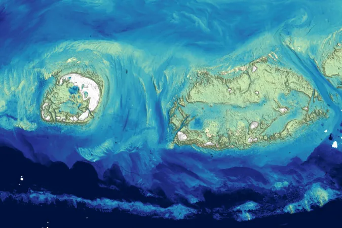
Scientists at the U.S. Geological Survey (USGS) have introduced a groundbreaking method to measure ocean depth—known as bathymetry—in shallow coastal waters, utilizing Landsat data. This transformative technique enables researchers to map the seafloor from space without needing prior depth measurements, revolutionizing coastal studies. By applying an advanced physics-based algorithm to satellite imagery, the USGS is addressing significant gaps in coastal mapping while providing essential information for modeling water movements, tracking changes along coastlines, and examining coral reef habitats.
The method leverages visible-light observations from the Operational Land Imager (OLI) and its successor, OLI-2, on the Landsat 8 and 9 satellites. By analyzing how sunlight interacts with shallow waters, the researchers can determine water depth based on reflected light. While the calculations are more straightforward to execute in clear waters, complexities arise in environments influenced by sediment, plankton, or vegetation. To tackle this, the USGS team meticulously refined their algorithm to account for various factors affecting the accuracy of light reflection, enabling precise depth determination.
Initial applications of this technique have focused on coral reef zones, such as the renowned Florida Keys, which span 350 miles of vibrant marine biodiversity. The new bathymetric maps reveal intricate detail about these ecosystems, showcasing important features like shallow channels and coral formations that are vital for marine life survival. Remarkably, Minsu Kim, the lead developer of this method, highlights that water depths over 20 meters (65 feet) can be mapped in clear waters, significantly surpassing initial expectations.
Historically, bathymetric mapping has relied heavily on costly ship sonar and lidar technology, making it a labor-intensive venture. The pursuit of satellite-based solutions has a rich history, dating back to pioneering efforts by oceanographer Jacques Cousteau in the 1970s. During the NASA-Cousteau Bathymetry Experiment, an innovative collaboration tested Landsat's capabilities for depth measurement over clear waters. Cousteau's team demonstrated that Landsat could, in fact, measure depths of up to 22 meters (72 feet) under favorable conditions.
With these recent developments, the research team aims to expand their mapping efforts into areas like the Pacific Islands and large coastal sections of Alaska, which currently lack comprehensive bathymetric data. This endeavor is critical for predicting wave behavior, sediment transport, and understanding marine hazards unique to these regions. Remarkably, Danielson notes that in the U.S. alone, only 52% of coastal waters have been mapped, highlighting the pressing need for advanced approaches to data acquisition.
Establishing initiatives such as the National Ocean Mapping, Exploration, and Characterization (NOMEC) and the global Seabed 2030 project, researchers are working toward comprehensive mapping coverage. These efforts hold the promise of significantly improving our understanding of marine environments, biodiversity, and ecological changes associated with climate change.
By harnessing satellite technology for marine surveying, this study is not just a stepping stone for coastal mapping—it's a giant leap for Earth sciences. As knowledge of underwater terrains expands, so too does the potential for better environmental management, conservation efforts, and a sustainable future for our invaluable oceans!


 Brasil (PT)
 Canada (EN)
 Chile (ES)
 Česko (CS)
 대한민국 (KO)
 España (ES)
 France (FR)
 Hong Kong (EN)
 Italia (IT)
 日本 (JA)
 Magyarország (HU)
 Norge (NO)
 Polska (PL)
 Schweiz (DE)
 Singapore (EN)
 Sverige (SV)
 Suomi (FI)
 Türkiye (TR)
 الإمارات العربية المتحدة (AR)