Is Your Location in the Path of Totality? Key Insights to Ensure You Don’t Miss the Solar Eclipse!
2025-09-04
Author: Michael
The Hidden Flaw in Solar Eclipse Maps
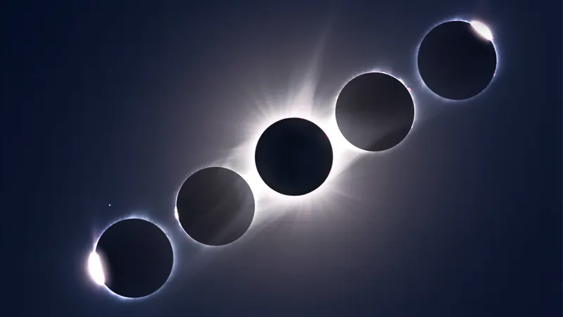
Solar eclipse maps may look neat with their clear lines defining the path of totality, where the spectacular total solar eclipse is best viewed. But these lines can be misleading! The edges of the path are often ambiguous and can be off by hundreds of meters, putting many viewers at risk of missing the breathtaking sight of the sun’s corona—one of nature’s most spectacular views.
This is especially crucial for areas like Madrid and Bilbao or small towns in Spain and Iceland during the upcoming total solar eclipse on August 12, 2026. If you’re at the edge, even a minor discrepancy can mean the difference between witnessing totality and only catching a glimpse of a crescent sun through glasses.
Why Are Eclipse Maps So Inaccurate?
The crisp lines we rely on are based on outdated calculations that assume the sun is a perfectly spherical body. For over a century, solar calculations used a standard solar radius of about 696,000 kilometers. However, recent findings suggest this figure is off. According to eclipse researcher Luca Quaglia, the sun’s apparent size is actually closer to 959.95 arc seconds, causing shifts in the edge of the totality path that can extend up to 600 meters!
Testing the New Measurements
Rather than staying at the coveted centerline during eclipses, Quaglia and his team study the edges to recalibrate their findings. They utilize GPS-timed flash spectra during eclipses to accurately track moments when sunlight first peaks through lunar valleys, a phenomenon known as Baily’s beads, which indicates the start and end of totality.
Navigating the 'Zone of Uncertainty'
To address the inaccuracies in the edges of the totality path, Quaglia's team has developed specialized eclipse maps for Spain that diverge significantly from traditional ones. These maps feature a 'zone of uncertainty' instead of a rigid boundary, accounting for the sun's fuzzy edges and the unpredictable visibility of the solar corona.
Impact of the Moon’s Surface
The moon presents its own set of challenges. Unlike traditional maps that assume a smooth lunar surface, the moon has valleys and mountains that allow light to peek through. This uneven topography can shift the timing of the eclipse by as much as 5 kilometers.
Innovative 3D Mapping Solutions
To overcome these obstacles, mathematicians are creating 3D eclipse maps. By accounting for the sun's radius, the moon's true shape, and Earth's terrain, they offer a more accurate prediction of the totality experience. Quaglia’s innovative approach produces detailed maps with jagged edges and terrain features that significantly affect visibility.
The Challenge of Variable Stars
The sun itself is a variable star, meaning its size fluctuates due to magnetic activity. This adds another layer of uncertainty for eclipse mapping. The changing conditions require ongoing measurements to ensure predictions remain as accurate as possible.
Your Best Bet for Viewing Totality!
So for those living near the totality path during the eclipse: play it safe! Move a mile or two towards the centerline to maximize your chance of witnessing the majestic moment of totality. With clear skies, you’re almost guaranteed an unforgettable experience!


 Brasil (PT)
 Canada (EN)
 Chile (ES)
 Česko (CS)
 대한민국 (KO)
 España (ES)
 France (FR)
 Hong Kong (EN)
 Italia (IT)
 日本 (JA)
 Magyarország (HU)
 Norge (NO)
 Polska (PL)
 Schweiz (DE)
 Singapore (EN)
 Sverige (SV)
 Suomi (FI)
 Türkiye (TR)
 الإمارات العربية المتحدة (AR)