Hurricane Helene: The Storm That Left 700+ mm of Rain and Historic Flooding in Its Wake!
2024-09-28
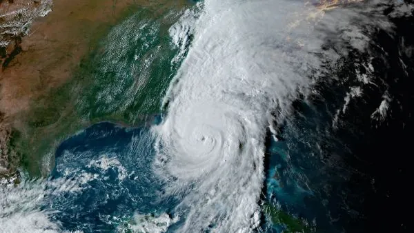
Hurricane Helene has etched its name into the annals of weather history, not only for its unprecedented winds but for the catastrophic flooding that ravaged the southeastern United States.
Making landfall on September 26, Hurricane Helene struck Florida with maximum winds reaching a staggering 225 km/h. The hurricane's impact was immense, causing destruction along the coast, but its most devastating legacy will be the floods that ensued.
In a shocking turn of events, some regions received over 700 mm of rain within just three days, transforming landscapes and submerging entire communities under relentless water. But how did a hurricane, known for its fierce winds, unleash such devastating rainfall before even making landfall?
The Brief But Powerful Ascent of Helene
Hurricane Helene intensified rapidly into a Category 4 storm as it approached land. Spanning a massive 700 km, the storm bore down on the Florida Panhandle, bringing with it damaging winds and an alarming storm surge that reached up to 4.5 meters in some areas. Neighborhoods were left in shambles, with homes swept away as saltwater flooded streets and properties.
Precursor Torrential Rains
Interestingly, the torrential downpours began well before Helene made landfall. This phenomenon, known as a predecessor rain event (PRE), happens when a tropical system’s arrival triggers a long, sustained batch of heavy rain. In Helene’s case, a strong upper-level trough over the southern U.S. funneled abundant tropical moisture, resulting in an extraordinary rainfall event across the Carolinas and Georgia.
As the storm brewed in the Gulf, parts of western North Carolina reported staggering rain totals of 200-300 mm days before Helene’s arrival, followed by another deluge once the storm passed through. The town of Busick, N.C. recorded an astonishing 751.3 mm (29.58 in.) of rain in a mere 48-hour period. Nearby Boone, home to Appalachian State University, also faced massive rainfall, with totals exceeding 330 mm. Even the Atlanta area received significant rainfall, between 300-350 mm, leading to widespread chaos.
A Region Underwater
The consequences were dire. The North Carolina Department of Transportation issued warnings, declaring all roads in western North Carolina impassable. Communities faced historic flooding as rivers and streams, already swollen from initial rains, became inundated with runoff from Helene's downpour.
For instance, the Swannanoa River in Biltmore, N.C. saw record-breaking levels, cresting at an unprecedented 26.10 ft (7.96 m), far surpassing the previous historic high of 20.70 ft set in 1916. Such intense flooding led to emergencies across the region, including dramatic rescues at the Unicoi County Hospital in Erwin, Tenn., where floodwaters engulfed the building.
The hospital's parent company reported that 54 people were stranded on the roof while seven remained in rescue boats, underscoring the storm's ferocity and the swift response required to save lives.
A Lesson for the Future
Hurricane Helene’s unprecedented rainfall and flooding serve as a somber reminder of nature’s power and unpredictability. Predecessor rain events are increasingly recognized for their potential to create severe flooding well in advance of a storm’s landfall, a phenomenon that communities along the southeastern coast must prepare for in the future. As climate change continues to influence weather patterns, experts warn that such catastrophic flooding events could become even more common.


 Brasil (PT)
 Canada (EN)
 Chile (ES)
 España (ES)
 France (FR)
 Hong Kong (EN)
 Italia (IT)
 日本 (JA)
 Magyarország (HU)
 Norge (NO)
 Polska (PL)
 Schweiz (DE)
 Singapore (EN)
 Sverige (SV)
 Suomi (FI)
 Türkiye (TR)