How Satellites are Saving the Endangered Right Whales by Tracking Their Tiny Meals
2025-05-11
Author: Amelia
In the chilly waters off New England, one of the planet's most endangered creatures—the North Atlantic right whale—glides through the ocean. With its mouth wide open, it sifts through vast clouds of tiny, red zooplankton known as Calanus finmarchicus, which are as small as grains of rice but crucial for the whale's survival. Unfortunately, only around 370 of these majestic whales remain.
A Revolutionary Approach to Zooplankton Tracking
For years, scientists had to venture out to sea, capturing zooplankton using nets and counting them by hand. But now, a team of innovative researchers has turned the tables and is using NASA satellite technology to spot these vital swarms from above.
Employing satellite data to track Calanus in the Gulf of Maine, scientists have found a method to detect these zooplankton’s distinctive red pigment. This groundbreaking research could change how we understand whale feeding habits and help protect these gentle giants.
Why This Matters for Whales and Maritime Industries
Knowing where these tiny animals gather can not only assist in protecting the right whales but also benefit commercial shipping and fishing industries. By predicting feeding locations, researchers aim to minimize dangerous vessel strikes and entanglements in fishing gear, two significant threats to this species. Optimizing this knowledge can mean safer seas and smarter business practices.
How it Works: The Science Behind the Satellites
The new technique utilizes NASA’s Aqua satellite and its MODIS (Moderate Resolution Imaging Spectroradiometer) instrument. Instead of observing the zooplankton directly, MODIS measures subtle changes in sunlight reflected from the ocean surface, influenced by the presence of the reddish pigment astaxanthin, which colors both the zooplankton and salmon.
As these tiny creatures rise to the surface, they alter how light is scattered in the water, leaving behind a signature that satellites can recognize. Catherine Mitchell, a satellite oceanographer at Bigelow Laboratory, noted, "We didn’t know to look for Calanus in this way before. This new method could reveal patterns of zooplankton that influence overall ocean ecology!"
Mapping Hidden Ecosystems
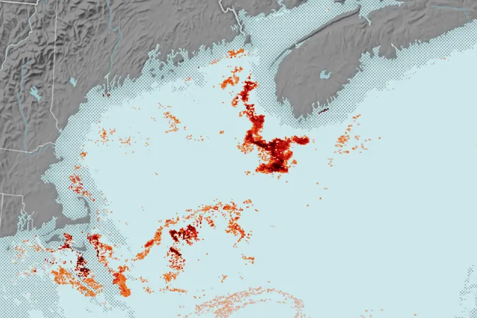
Researchers had previously piloted this technique in Norwegian waters. Now, their refined approach has been applied to the Gulf of Maine, which is critical for right whales during migration. By combining satellite data with field measurements, they’ve unveiled swarms of Calanus at the ocean’s surface, estimating densities that can reach an astonishing 150,000 individuals per cubic meter.
What’s fascinating is how this satellite technology reveals feeding patterns undetectable to the human eye, showcasing intricate swarms southwest of Nova Scotia and less dense clusters within the Gulf.
A Bright Future for Endangered Whales
Rebekah Shunmugapandi, who led the study, emphasized the power of this information: "We are still uncovering unknown feeding grounds and travel routes for these whales. This satellite data could be a game-changer in marine conservation!"
With NASA’s ongoing support, this innovative research connects space-based observation directly to the pressing challenges of our oceans, making strides in protecting both marine life and commercial interests for future generations.


 Brasil (PT)
 Canada (EN)
 Chile (ES)
 Česko (CS)
 대한민국 (KO)
 España (ES)
 France (FR)
 Hong Kong (EN)
 Italia (IT)
 日本 (JA)
 Magyarország (HU)
 Norge (NO)
 Polska (PL)
 Schweiz (DE)
 Singapore (EN)
 Sverige (SV)
 Suomi (FI)
 Türkiye (TR)
 الإمارات العربية المتحدة (AR)