Discovering the Depths: Unveiling the International Bathymetric Chart of the Arctic Ocean Version 5.0
2025-01-12
Author: Charlotte
Introduction
In the ever-evolving field of marine science, understanding the seafloor depth—known as bathymetry—is critical for a multitude of activities. These range from scientific research and navigation safety to offshore exploration and resource extraction. With the Arctic Ocean rapidly becoming a focal point of scientific inquiry, accurate mapping of its depths has never been more essential.
Challenges in Mapping the Arctic Ocean
Mapping the central Arctic Ocean has presented significant challenges due to the dominating presence of perennial sea ice. This has restricted data collection capabilities primarily to icebreakers, submarines, and specially-equipped drifting ice stations. The harsh conditions of this remote environment have made it difficult for researchers to thoroughly assess and document the ocean floor.
The IBCAO Initiative
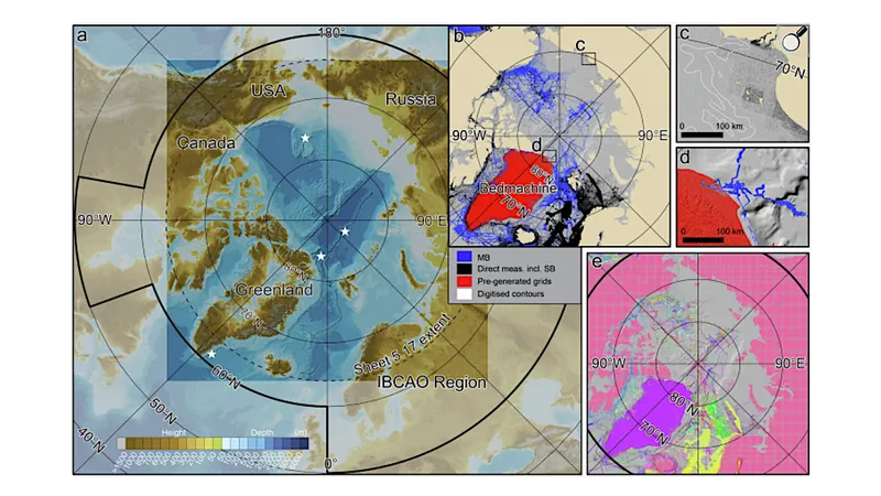
The International Bathymetric Chart of the Arctic Ocean (IBCAO) is a groundbreaking initiative that was launched in 1997, aiming to provide a comprehensive portrayal of the Arctic Ocean's bathymetry. Over the years, the IBCAO project has led to the release of four iterations, each progressively enhancing the resolution and accuracy of the seafloor mapping.
IBCAO Version 5.0
The latest release, IBCAO Version 5.0, marks a significant milestone in this endeavor. This new version boasts a remarkable fourfold increase in resolution compared to its predecessor, Version 4.0, utilizing grid cells of 100 × 100 meters instead of the earlier 200 × 200 meters. In an impressive feat, more than 25% of the Arctic Ocean has now been documented with specific depth soundings based on sophisticated criteria relating to varying water depths.
Advancements and Challenges
This latest version also showcases advancements in data compilation and computing techniques, making it a vital tool for researchers and policy-makers alike. Despite these notable strides, challenges remain, including ice cover and ongoing political dynamics that can complicate the mapping process.
Conclusion
With the reveals of the IBCAO 5.0, scientists are now more equipped than ever to understand the complexities of the Arctic seabed, paving the way for further exploration in this increasingly crucial region of our planet. As we venture into an era driven by climate change and geopolitical interests, the insights gained from such detailed bathymetric data could reshape our understanding of marine ecosystems, navigation routes, and potential resource discoveries in the Arctic. The International Bathymetric Chart of the Arctic Ocean Version 5.0 is not just a map; it's a gateway to unlocking the secrets of one of the Earth's last frontiers.


 Brasil (PT)
 Canada (EN)
 Chile (ES)
 Česko (CS)
 대한민국 (KO)
 España (ES)
 France (FR)
 Hong Kong (EN)
 Italia (IT)
 日本 (JA)
 Magyarország (HU)
 Norge (NO)
 Polska (PL)
 Schweiz (DE)
 Singapore (EN)
 Sverige (SV)
 Suomi (FI)
 Türkiye (TR)
 الإمارات العربية المتحدة (AR)