Breathtaking Dust Plume Engulfs China's Tarim Basin
2025-04-13
Author: Noah
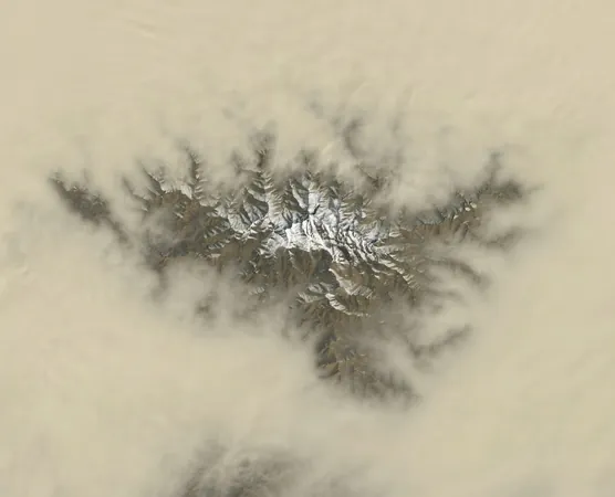
NASA Captures Stunning Image of Tarim Basin Under Dust
A recent breathtaking image from NASA Earth Observatory showcases the Tarim Basin in northwestern China, where a thick layer of dust blankets the arid landscape. The majestic Tekilik Shan mountain range, a hidden jewel of the Kunlun Mountains, peeks through the haze, reminding us of nature's stark beauty.
Springtime Dust Storm Chaos
As spring unfolds, the Tarim Basin becomes a hotspot for dust storms, particularly in its southern regions. NASA notes that this season sees a shift in regional winds, bringing powerful gusts from the northwest. Under the relentless sun, the dry landscape, stripped of vegetation, warms rapidly, creating convection currents that propel dust high into the atmosphere.
Nature's Fingerprint: Dust Formations
Incredible satellite imagery reveals fingerlike dust formations tracing the valleys below, where the terrain effectively channels the airborne particles. Ralph Kahn, an atmospheric scientist, suggests that this dust could be 'self-lofting'—a fascinating process where heated surface dust creates convection pockets that lift it ever higher.
Declining Dust Levels: A Silver Lining?
Interestingly, satellite data from MODIS indicates that dust levels in this area have been on a gradual decline—around 1.5% annually since the early 2000s. Researcher Hongbin Yu attributes this drop to changes during the spring, such as variations in wind speeds and soil moisture, rather than seasonal shifts.
The Harsh Reality of the Tarim Basin
Without a doubt, the Tarim Basin, home to the notorious Taklamakan Desert, stands as one of Earth’s driest places. Here, rainfall can dip below 10 millimeters (0.4 inches) each year. These dust storms not only create public health challenges by sending tiny particles, bacteria, and viruses into the air but also have far-reaching effects on global climate by altering solar radiation and cloud properties.
The Enigmatic Geography of the Tarim Basin
The Tarim Basin, one of the world's largest endorheic basins, challenges our understanding of geography as its rivers do not reach the sea but vanish into internal lakes or evaporate. Surrounded by mighty mountain ranges—the Tien Shan, Kunlun, and Pamirs—the region experiences a severe rain shadow effect, intensifying its aridity.
A Historical Crossroads Mines for Resources
Beyond its natural challenges, the Tarim Basin has played a significant role in human history. It was a vital segment of the ancient Silk Road, with oases like Kashgar and Khotan once bustling with trade and culture. Today, its geological wealth—particularly oil and natural gas—positions it as a focal point for China’s energy pursuits, even as its harsh climate complicates infrastructure and habitation.
Captured from Above
This stunning visual was captured on March 27, 2025, by the Operational Land Imager on Landsat 8, further illuminating the breathtaking yet harsh beauty of this crucial region.


 Brasil (PT)
 Canada (EN)
 Chile (ES)
 Česko (CS)
 대한민국 (KO)
 España (ES)
 France (FR)
 Hong Kong (EN)
 Italia (IT)
 日本 (JA)
 Magyarország (HU)
 Norge (NO)
 Polska (PL)
 Schweiz (DE)
 Singapore (EN)
 Sverige (SV)
 Suomi (FI)
 Türkiye (TR)
 الإمارات العربية المتحدة (AR)